
Nanteuil-en-Vallée
| Nanteuil-en-Vallée | ||
|---|---|---|
|
||
| region | Nouvelle-Aquitaine | |
| Department | Charente | |
| Arrondissement | Confolens | |
| Canton | Charente North | |
| Community association | Val de Charente | |
| Coordinates | 46 ° 0 ′ N , 0 ° 19 ′ E | |
| height | 82-218 m | |
| surface | 68.85 km 2 | |
| Residents | 1,359 (January 1, 2017) | |
| Population density | 20 inhabitants / km 2 | |
| Post Code | 16700 | |
| INSEE code | 16242 | |
 Town hall (Mairie) of Nanteuil-en-Vallée |
||

Nanteuil-en-Vallée is a French commune with 1,359 inhabitants (as of January 1 2017) in the department of Charente in the region Nouvelle-Aquitaine ; it belongs to the Arrondissement Confolens and the canton Charente-Nord (until 2015: canton Ruffec ). The inhabitants are called Nanteuillais .
geography
Nanteuil-en-Vallée is about 41 kilometers north-northeast of Angoulême . Nanteuil-en-Vallée is surrounded by the neighboring communities of Lizant in the north and northwest, Genouillé in the north, Le Bouchage in the northeast, Vieux-Ruffec and Champagne-Mouton in the east, Chassiecq in the southeast, Saint-Gourson in the south, Poursac and Saint-Georges in the south-west, Verteuil-sur-Charente in the west and south-west, Barro and Bioussac in the west and Taizé-Aizie in the north-west.
Population development
| year | 1962 | 1968 | 1975 | 1982 | 1990 | 1999 | 2006 | 2013 |
| Residents | 637 | 557 | 1,545 | 1,449 | 1,496 | 1,395 | 1,445 | 1,389 |
| Source: Cassini and INSEE | ||||||||
Attractions
- Notre-Dame monastery of Nanteuil, founded in 780, remains of the foundations from this period, structures from the 12th century that are preserved today, monument historique since 1943
- Saint-Jean-Baptiste church, monument historique since 1989
- Boisaugeais Chapel from the 15th century, historic monument since 1992
- Aizecq mansion with dovecote, monument historique since 2002
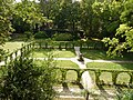
Ruins of the former chapter house of the Notre-Dame monastery
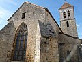
Saint-Jean-Baptiste church

Chapel of Boisaugeais

Aizecq mansion


