
Roussines (Charente)
| Roussines | ||
|---|---|---|
.svg)
|
|
|
| region | Nouvelle-Aquitaine | |
| Department | Charente | |
| Arrondissement | Confolens | |
| Canton | Charente-Bonnieure | |
| Community association | Charente limousine | |
| Coordinates | 45 ° 43 ' N , 0 ° 37' E | |
| height | 147-281 m | |
| surface | 16.08 km 2 | |
| Residents | 283 (January 1, 2017) | |
| Population density | 18 inhabitants / km 2 | |
| Post Code | 16310 | |
| INSEE code | 16289 | |
 Roussines as seen from the Mairie |
||

Roussines , Occitan Rossinas is a French municipality with 283 inhabitants (at January 1, 2017) in the department of Charente in the region Nouvelle-Aquitaine (before 2016 Aquitaine ). It belongs to the Arrondissement Confolens and the canton Charente-Bonnieure (until 2015 canton Montembœuf ). The inhabitants are called Roussinois or Roussinoises .
etymology
The origin of the place name Roussines is likely to be traced back to the Gallo-Roman proper name Ruscinius or Russinus , in turn derived from Russus . In 1280 the place was known as Runciniis or Rossinis and in 1444 as Rossines .
geography
Roussines is a border municipality to both the Dordogne and Haute-Vienne departments . It is surrounded by the following 6 neighboring communities:
| Le Lindois | Sauvagnac | |
| Rouzède |
.svg)
|
Maisonnais-sur-Tardoire (Haute-Vienne) |
| Écuras | Busserolles (Dordogne) |
Roussines is located 8 kilometers southeast of Montembœuf , 11 kilometers northeast of Montbron and 11 kilometers west of Saint-Mathieu . It is 37 kilometers to Angoulême in the west and 51 kilometers to Limoges in the east. Confolens to the north is 33 kilometers away.
The average height of the municipality is 220 meters above sea level . The maximum height differences are 134 meters, with the lowest point on the Tardoire in the south at 147 meters and the highest point at 281 meters on the northern border with the neighboring municipality of Le Lindois . The town center is located at 238 meters.

Larger towns in the municipality of Roussines are Écossas , La Madrinie , La Séchère , Lavallade , Le Boin , Le Montizon , Magnanon and Roussines . Smaller towns, hamlets, farms, estates, mills and landmarks are Bellac , Bos de Samaroux , Chez Caillaud , Chez Conton , Chez Lotte , Chez Piroux , Chez Thibaud , Étangs de Montizon , Étang de la Grole , La Majeunie , La Prade , Le Bois de l'Age , Le Buisson , le Clos , Le Gros Chêne , Le Fayon , Le Moulin de Roussines , Le Pont , Le Pont Rouchaud , le Recoudet , Le Village Neuf , Les Brousses , Les Brunetiers , Les Brunies , Les Fontaines Claires , Les Fossés , Les Frauds , Les Gravets , Les Landes , Les Landes de Placant , Les Mottes , Les Sèches , Les Vignes and Samaroux .
Transport links
The center of Roussines is crossed in a north-westerly direction by the D 50 (or D 88 in the Dordogne) from Busserolles to Le Lindois. The D 163 leaves the town center in a north-easterly direction to Sauvagnac. In addition, the D 163 branches off from the center to Écuras in the southwest. The municipal boundary in the north touches the D 27 (or D 34 in Haute-Vienne) coming from Les Salles-Lavauguyon in the east. Smaller municipal roads provide the connection to the scattered villages and hamlets.
Hydrography

The municipality of Roussines is drained by the Tardoire and its small right tributaries. The Tardoire forms the département border to Haute-Vienne (Maisonnais-sur-Tardoire) and the Dordogne (Busserolles) and flows off to the southwest. The first right tributary of the Tardoire is the Suchés , which extends the municipal boundary opposite the Haute-Vienne to the north. Other right tributaries coming from the north are the Ruisseau de Logeat , the Ruisseau de la Peyre and the Ruisseau de Montizon . The Ruisseau de la Peyre flows into the Ruisseau de Logeat and forms the border with the neighboring municipality of Sauvagnac. The Ruisseau de Montizon rises in the municipality of Le Lindois and then runs west past the town center and south towards Tardoire.
The relatively water-impermeable soil favors many smaller ponds and reservoirs in the municipality.
geology

The municipality of Roussines is underlain in its entirety by the metamorphic basement of the northwestern Massif Central . It is structurally on the northern edge of the Saint-Mathieu-Doms . The main rocks are granitoids and gneisses .
Paragneiss ( ζ 1-2 ) and migmatitic paragneiss ( Metatexite - Mζ 1-2 ), with which the microgranites ( μ γ 3M ) of the northern apophysis of the Piégut-Pluviers-Granodiorite are associated, are in the southern part of the municipality . The paragneiss generally strike northeast and dip at 30 to 60 ° to the northwest.
Further north follows the north-west wing of the Saint-Mathieu-Leukogranite, which is sheared along the Montbron fault . It begins with the Roussines leukogranite ( γζ 1-2 ) - a strongly tectonized facies with SC structure , which has its type locality here . The coplanar fine-grained facies ( γ 2M ) and the fine-grained facies ( Champniers-Reilhac-Leukogranit - γ 2 ) follow further north . The foliation of the leuco granites - so recognizable - strikes northeast and falls at 21 to 60 ° to the northwest and thus runs parallel to the orientation of the paragneiss.
All leukogranitic facies are interspersed with several N 000 and N 020 striking microgranite dikes ( μ γ - at Écossas and Le Boin ) and by two small lamprophyric bodies (microdiorites - μ η 1-2 - at Lavallade and Le Moulin de Roussines ).
Some faults pervade the basement - they strike north-northwest and north-northeast (mostly).
At Les Frauds and Les Vignes , the Pleistocene colluvium covers the basement. It is clays and sands with gravel layers of reclaimed basement material.
The valleys of the Tardoire and the Ruisseau de Montizon are filled with Holocene alluvium - brick-red clays with basement rubble .
Ecology and environment
Roussines is a very wooded municipality with a tree population of around 50% of the municipality's area. Livestock is farmed in the meadows, mainly with cattle of the Limousin breed .
Climatically, there is a weaker maritime climate typical of the Charente limousine , which has lower temperatures and higher rainfall than the rest of the Charente department.
history
At Les Mottes , a circular rampart with a diameter of 55 meters could still be seen in the 19th century, which indicated an old settlement. Its exact age is unknown, possibly early history , but it may only go back to the Middle Ages . The local church Saint-Jacques was in the 11th / 12th. Built in the 17th century and is Romanesque architectural style . The oldest church book in the parish dates back to 1648. Like Montbron, Roussines lay during the Middle Ages on an east-west branch of the Way of St. James , which had the relics of Saint Eutropius in Saintes as a pilgrimage destination . Roussines owns one of the seven St. James churches in Charente. During the Ancien Régime there were important blacksmiths at Le Montizon . The Château d'Écossas once belonged to the Dauphin family.
Population development
| Population development in Roussines | ||
|---|---|---|
| year | Residents |

|
| 1962 | 577 | |
| 1968 | 504 | |
| 1975 | 442 | |
| 1982 | 396 | |
| 1990 | 374 | |
| 1999 | 301 | |
| 2006 | 310 | |
| 2007 | 311 | |
| 2012 | 264 | |
| 2016 | 275 | |
| 2017 | 283 | |
Source: INSEE
The population of Roussines has generally declined with slight fluctuations since 1962 (total loss of 51 percent).
With an area of 16.08 square kilometers, the population density of the municipality is 18 inhabitants / km².
mayor
The mayor of Roussines has been the non-party Danielle Chagnaud since April 2014.
Attractions
- the parish church of Saint-Jacques from 11/12. century
- the Pont Rouchaud forge from 1792
- the Château de Bellat (ruin).
Photo gallery
 Saint-Jacques and Church Square
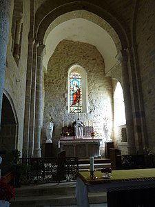 Interior of Saint-Jacques
 Mairie from Roussines
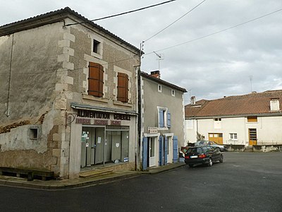 Central square in front of the church
 Large linden tree in front of the Mairie
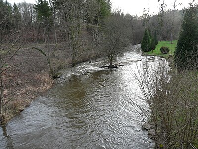 The Tardoire below the D 50, the municipality of Busserolles is on the left


literature
- A. Bambier et al .: La Rochefoucauld 1831 . In: Carte géologique de la France at 1/50 000 . BRGM, 1983.
- G. Le Pochat et al. a .: Feuille Montbron . In: Carte géologique de la France at 1/50 000 . BRGM, 1986.
Web links
- Roussines on the annuaire-mairie.fr website
- Roussines on cartesfrance.fr in French
- Population development since 1793 on cassini.ehess.fr
Individual evidence
- ^ Albert Dauzat and Charles Rostaing: Dictionnaire étymologique des noms de lieux en France . Librairie Guénégaud, Paris 1989, ISBN 2-85023-076-6 , pp. 738, page 577 .
- ^ Roussines on the Insee website