
Vars (Charente)
| Vars | ||
|---|---|---|
.svg)
|
|
|
| region | Nouvelle-Aquitaine | |
| Department | Charente | |
| Arrondissement | Confolens | |
| Canton | Boixe-et-Manslois (main town) | |
| Community association | Coeur de Charente | |
| Coordinates | 45 ° 46 ′ N , 0 ° 7 ′ E | |
| height | 35-153 m | |
| surface | 27.46 km 2 | |
| Residents | 2,081 (January 1, 2017) | |
| Population density | 76 inhabitants / km 2 | |
| Post Code | 16330 | |
| INSEE code | 16393 | |
| Website | www.mairie-vars16.fr | |
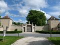
 Town hall (Mairie) of Vars |
||

Vars is a French commune with 2,081 inhabitants (as of January 1 2017) in the department of Charente in the region Nouvelle-Aquitaine ; it belongs to the arrondissement of Confolens and the canton of Boixe-et-Manslois (until 2015: canton of Saint-Amant-de-Boixe ). The inhabitants are called Varsois .
geography
Vars is about 13 kilometers north of Angoulême on the Charente . Vars is surrounded by the neighboring communities of Montignac-Charente in the north and north-west, Saint-Amant-de-Boixe in the north and north-east, Tourriers in the north-east, Anais in the east, Champniers in the south-east, Balzac in the south, Vindelle in the south and south-west and Marsac in the West and southwest.
The Route nationale 10 runs along the eastern edge of the municipality .
Population development
| 1962 | 1968 | 1975 | 1982 | 1990 | 1999 | 2006 | 2017 |
|---|---|---|---|---|---|---|---|
| 1089 | 1306 | 1340 | 1551 | 1511 | 1567 | 1804 | 2081 |
Attractions
- Saint-Denis church, neo-Romanesque church building from the 16th century
- House Le Portal
- Mill
- Wash house

Saint-Denis church
House Le Portal
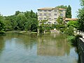
Watermill on the Charente

Wash house


Personalities
- Octavien de Saint-Gelais (1468–1502), cleric and poet