Épenède
| Épenède | ||
|---|---|---|
|
|
||
| region | Nouvelle-Aquitaine | |
| Department | Charente | |
| Arrondissement | Confolens | |
| Canton | Charente-Vienne | |
| Community association | Charente limousine | |
| Coordinates | 46 ° 4 ' N , 0 ° 32' E | |
| height | 144-194 m | |
| surface | 15.62 km 2 | |
| Residents | 185 (January 1, 2017) | |
| Population density | 12 inhabitants / km 2 | |
| Post Code | 16490 | |
| INSEE code | 16128 | |
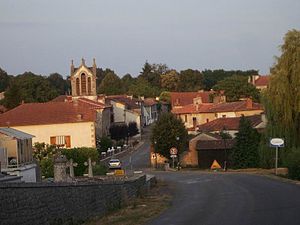
 Townscape with Saint-Hilaire church |
||
Épenède is a place and a community with 185 inhabitants (at January 1, 2017) in western France Charente in the region Nouvelle-Aquitaine . Several individual farms belong to the community .
location
The place Épenède is at an altitude of about 168 m above sea level. d. M. in the north of the Charente department in the old cultural landscape of southern Poitou or northern Angoumois , part of the Charente landscape . The Transon River runs along the southwestern municipal boundary . The place is about 67 km (driving distance) northeast of the city of Angoulême ; It is around 66 km north to Poitiers . The small town of Confolens is only about 12 km away.
Population development
| year | 1800 | 1851 | 1901 | 1954 | 1999 | 2013 |
| Residents | 510 | 586 | 468 | 350 | 209 | 221 |
The continuous decline in population since the late 19th century is mainly due to the loss of jobs as a result of the phylloxera crisis in viticulture and the increasing mechanization of agriculture .
economy
The place and its surroundings were dominated by agriculture for centuries; most of the people lived on their fields and gardens as self-sufficient . In the late Middle Ages and in the early modern period, viticulture was promoted, but - after the phylloxera crisis in the late 19th and early 20th centuries - it was almost stopped and its former importance is still today, despite its location in the Bon Bois of the Cognac wine-growing region has not recovered. Since the 1960s tourism has played a not insignificant role in the economic life of the municipality in the form of renting out holiday homes ( gîtes ) .
history
No finds are known from Roman or Gallo-Roman times. The area formerly part of the historical province of Poitou was annexed by the Counts of Angoulême in the 11th or 12th century . The church, built around 1200, belonged to a vicariate of the Poitiers diocese ; it was administered by the Charroux Abbey . Nothing is known about the destruction during the Hundred Years' War (1337–1453) or the Huguenot Wars (1562–1598); during the French Revolution the church was set on fire.
Attractions
The parish church of Saint-Hilaire, which is largely made of quarry stones, is single-nave building from the late 12th or early 13th century. The nave lost its vaults due to a fire during the revolutionary years, which was replaced by a wooden ceiling in 1846. The bell tower dates back to 1875. The church has been recognized as a monument historique since 1965 .
Web links
Individual evidence
- ↑ Épenède - Viticulture
- ↑ Église Saint-Hilaire, Épenède in the Base Mérimée of the French Ministry of Culture (French)
- ↑ Église Saint-Hilaire, Épenède in the Base Mérimée of the French Ministry of Culture (French)

