
Nieuil
| Nieuil | ||
|---|---|---|
|
||
| region | Nouvelle-Aquitaine | |
| Department | Charente | |
| Arrondissement | Confolens | |
| Canton | Charente-Bonnieure | |
| Community association | Charente limousine | |
| Coordinates | 45 ° 53 ' N , 0 ° 30' E | |
| height | 128-218 m | |
| surface | 23.9 km 2 | |
| Residents | 932 (January 1, 2017) | |
| Population density | 39 inhabitants / km 2 | |
| Post Code | 16270 | |
| INSEE code | 16245 | |
 Town Hall (Mairie) and Nieuil School |
||

Nieuil is a French municipality with 932 inhabitants (at January 1, 2017) in the department of Charente in the region Nouvelle-Aquitaine (before 2016 Poitou-Charentes ); it belongs to the Arrondissement Confolens and the canton Charente-Bonnieure (until 2015 Saint-Claud ).
geography
The place is about 30 kilometers northeast of Angoulême on the Son , a tributary of the Charente . Nieuil is surrounded by the neighboring parishes of Saint-Claud in the west and north,
- Terres-de-Haute-Charente in the north and east, Suaux in the south and Lussac in the south-west.
Population development
| year | 1793 | 1856 | 1901 | 1962 | 1968 | 1975 | 1982 | 1990 | 1999 | 2006 | 2013 |
|---|---|---|---|---|---|---|---|---|---|---|---|
| Residents | 1,165 | 1,492 | 1,348 | 1,043 | 1,021 | 941 | 931 | 954 | 907 | 927 | 920 |
| Source: Cassini and INSEE | |||||||||||
Attractions
- Saint-Vivien church from the 16th century
- Nieuil Castle, now a hotel, built at the end of the 19th century

Saint Vivien Church
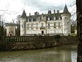
Nieuil Castle


Web links
Commons : Nieuil - collection of images, videos and audio files