
Suaux
|
Suaux Suaus |
||
|---|---|---|

|
|
|
| region | Nouvelle-Aquitaine | |
| Department | Charente | |
| Arrondissement | Confolens | |
| Canton | Charente-Bonnieure | |
| Community association | Charente limousine | |
| Coordinates | 45 ° 51 ′ N , 0 ° 30 ′ E | |
| height | 120-212 m | |
| surface | 11.93 km 2 | |
| Residents | 390 (January 1, 2017) | |
| Population density | 33 inhabitants / km 2 | |
| Post Code | 16260 | |
| INSEE code | 16375 | |
| Website | http://www.suaux.fr/ | |
 Town hall (Mairie) of Suaux |
||

Suaux is a French municipality with 390 inhabitants (as of January 1 2017) in the department of Charente in the region Nouvelle-Aquitaine (before 2016 Poitou-Charentes ); it belongs to the Arrondissement Confolens and the canton Charente-Bonnieure (until 2015 Saint-Claud ).
geography
Suaux is about 35 kilometers northeast of Angoulême . Suaux is surrounded by the neighboring communities
- Nieuil in the north,
- Terres-de-Haute-Charente with Genouillac in the east and northeast and Mazières in the east and southeast,
- Cherves-Châtelars in the south,
- Vitrac-Saint-Vincent in the south and south-west,
- Chasseneuil-sur-Bonnieure in and south-west,
- Lussac in the west.
Population development
| year | 1793 | 1856 | 1901 | 1962 | 1968 | 1975 | 1982 | 1990 | 1999 | 2006 | 2013 |
|---|---|---|---|---|---|---|---|---|---|---|---|
| Residents | 891 | 870 | 769 | 509 | 484 | 460 | 373 | 367 | 356 | 369 | 420 |
| Source: Cassini and INSEE | |||||||||||
Attractions
- Saint-Cybard church from the 13th century
- Suaux Castle, built in 1585, today's town hall
- House Brassac

Saint-Cybard Church
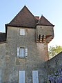
Suaux Castle (today's town hall)


Web links
Commons : Suaux - collection of images, videos and audio files