
Villejoubert
| Villejoubert | ||
|---|---|---|
|
||
| region | Nouvelle-Aquitaine | |
| Department | Charente | |
| Arrondissement | Confolens | |
| Canton | Boixe-et-Manslois | |
| Community association | Coeur de Charente | |
| Coordinates | 45 ° 51 ′ N , 0 ° 11 ′ E | |
| height | 73-146 m | |
| surface | 7.82 km 2 | |
| Residents | 332 (January 1, 2017) | |
| Population density | 42 inhabitants / km 2 | |
| Post Code | 16560 | |
| INSEE code | 16412 | |
 City Hall (Mairie) of Villejoubert |
||

Villejoubert is a French municipality with 332 inhabitants (at January 1, 2017) in the department of Charente in the region Nouvelle-Aquitaine (before 2016 Poitou-Charentes ); it belongs to the Arrondissement Confolens ( Angoulême until 2017 ) and the canton Boixe-et-Manslois ( Saint-Amant-de-Boixe until 2015 ).
geography
Villejoubert is located about 25 kilometers north-northwest of Angoulême . Villejoubert is surrounded by the neighboring communities of Saint-Amant-de-Boixe in the north, south and west, Aussac-Vadalle in the north and east and Tourriers in the east and south-east.
Population development
| 1962 | 1968 | 1975 | 1982 | 1990 | 1999 | 2006 | 2013 |
|---|---|---|---|---|---|---|---|
| 139 | 127 | 165 | 256 | 279 | 293 | 326 | 337 |
| Source: Cassini and INSEE | |||||||
Attractions
- Saint-Lazare church, a historic monument since 1934
- La Mascarine Chapel from the 11th century
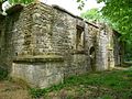
- Remains of the castrum of Andone from Gallo-Roman times (later probably a Carolingian fortress), Monument historique since 1986
- La Barre castle from the 15th century, monument historique since 1990

Saint-Lazare church
La Mascarine Chapel

Castrum Andone
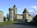
La Barre Castle


Web links
Commons : Villejoubert - collection of images, videos and audio files