
Puyréaux
| Puyréaux | ||
|---|---|---|
|
||
| region | Nouvelle-Aquitaine | |
| Department | Charente | |
| Arrondissement | Confolens | |
| Canton | Boixe-et-Manslois | |
| Community association | Coeur de Charente | |
| Coordinates | 45 ° 52 ' N , 0 ° 13' E | |
| height | 57-116 m | |
| surface | 8.11 km 2 | |
| Residents | 533 (January 1, 2017) | |
| Population density | 66 inhabitants / km 2 | |
| Post Code | 16230 | |
| INSEE code | 16272 | |
 Town hall (Mairie) of Puyréaux |
||

Puyréaux is a French municipality with 533 inhabitants (at January 1, 2017) in the department of Charente in the region Nouvelle-Aquitaine (before 2016 Poitou-Charentes ); it belongs to the arrondissement of Confolens and the canton of Boixe-et-Manslois (until 2015 Mansle ). The inhabitants are called Podio-Régaliens .
geography
Puyréaux is located about 23 kilometers north-northeast of Angoulême at the confluence of the Bonnieure in the Charente . Puyréaux is surrounded by the neighboring communities of Fontclaireau in the north and north-west, Mouton in the north, Saint-Ciers-sur-Bonnieure in the north and east, Nanclars in the south, Maine-de-Boixe in the west and south-west and Mansle in the north-west.
Population development
| 1962 | 1968 | 1975 | 1982 | 1990 | 1999 | 2006 | 2013 |
|---|---|---|---|---|---|---|---|
| 343 | 334 | 321 | 361 | 403 | 396 | 448 | 512 |
| Source: Cassini and INSEE | |||||||
Attractions
- Saint Laurent Church
- Le Châtelard house
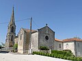
Saint Laurent Church
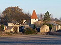
Le Châtelard house


Personalities
- Jean Léchelle (1760–1793), General de division