Paizay Naudouin Embourie
| Paizay Naudouin Embourie | ||
|---|---|---|
|
|
||
| region | Nouvelle-Aquitaine | |
| Department | Charente | |
| Arrondissement | Confolens | |
| Canton | Charente North | |
| Community association | Val de Charente | |
| Coordinates | 46 ° 2 ′ N , 0 ° 0 ′ W | |
| height | 78-155 m | |
| surface | 25.42 km 2 | |
| Residents | 368 (January 1, 2017) | |
| Population density | 14 inhabitants / km 2 | |
| Post Code | 16240 | |
| INSEE code | 16253 | |
 Mairie Paizay-Naudouin-Embourie |
||
Paizay-Naudouin-Embourie is a French municipality with 368 inhabitants (as of January 1 2017) in the Charente in the region Nouvelle-Aquitaine (2015 Poitou-Charentes ). The municipality belongs to the Arrondissement Confolens and the Val de Charente municipal association founded in 2014 . The inhabitants are called Paizéens .
geography
The municipality of Paizay-Naudouin-Embourie is located in the northwest of the Charente department on the edge of the historical Angoumois province on the border with the Deux-Sèvres department , halfway between Niort and Angoulême and about 75 kilometers from the Atlantic coast. The Aume , a right tributary of the Charente, flows through the gently sloping terrain of the municipality . With 25.42 km² Paizay-Naudouin-Embourie is one of the larger municipalities in the department. In addition to the eponymous villages Paizay Naudouin and Embourie, the municipality also includes the hamlets of Le Fouilloux, Puits Chauvet Bas, Puits Chauvet Haut, Rolaire, Bramefan, Tourteron, Le Peu, Les Moulins, Les Châgnerasses, Saveille, Les Défens, La Mardigrelle, Le Pontereau , Le Chêne, Les Justices, Fontgrolle, La Feuilletrie, Rondeau, Villeprévoir, Les Quéraux, Les Allards, Le Breuil Tison, Logis de Ferret and Frédière . Paizay-Naudouin-Embourie is surrounded by the neighboring communities of Hanc and Pioussay in the north, Theil-Rabier and La Magdeleine in the northeast, Empuré in the east, Longré in the south, Couture-d'Argenson in the southwest and Loubillé in the west.
Place names
The early names are Noduis in 1110, Paizai feudum (fortress) in 1242, Payzaco and Peizay in the 14th century, Paysaco 1326. The origin of the name Paizay goes back to a Gallo-Roman personal name Pasius, to which the suffix -acum is appended, which would correspond to Pasiacum (field of Pasius). The name Naudouin could go back to a Germanic name Audowin.
An old spelling of the village of Embourie is Emborisio . Its origin goes back to the Latin place name Emporium (the market). Another not favored interpretation sees the origin of the name derived from the Gallic Amborix .
In 1793 the municipality was called Paisais , in 1801 Pesay-Naudouin and Paizay-Naudouin . In 1973 the municipality of Paizay-Naudouin-Embourie was created through the merger with the previously independent municipality of Embourie .
Population development
| year | 1962 | 1968 | 1975 | 1982 | 1990 | 1999 | 2006 | 2016 |
| Residents | 564 | 573 | 583 | 514 | 493 | 423 | 405 | 375 |
| Sources: Cassini and INSEE | ||||||||
Attractions
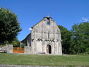
- Saint-Genis church in the village of Embourie from the 12th century, monument historique since 1987
- Gallo-Roman villa of Châteliers, freely accessible archaeological site in Embourie , showing various levels of settlement from the 1st to 4th centuries, Monument historique since 1983
- Château de Saveille in the district of Saveille , large rectangular castle building from the 15th and 16th centuries, surrounded by moats and flanked by corner turrets, monument historique
- Saint-Hilaire church in Paizay-Naudouin
- Accommodation in the Tourteron district
- Fallen memorial
- Lavoir
Economy and Infrastructure
The community is dominated by agriculture. There are 26 farms in Paizay-Naudouin-Embourie (cereal and vegetable growing, dairy farming).
Paizay-Naudouin-Embourie is located away from the nationally important traffic axes. In Ruffec , 15 kilometers to the east, there is a connection to the motorway-like RN 10 from Poitiers to Angoulême .
supporting documents
- ↑ Jean Nanglard, Livre des fiefs de Guillaume de Blaye, évêque d'Angoulême ["Liber feodorum"], t. 5, Société archéologique et historique de la Charente, 1905 (1re éd. 1273), 404 p. (lire en ligne [archive]), p. 34,161,245
- ↑ Jean Nanglard, Pouillé historique du diocèse d'Angoulême, t. III, Angoulême, imprimerie Despujols, 1900, 582 p., P. 199
- ↑ Jean Nanglard, Pouillé historique du diocèse d'Angoulême, t. III, Angoulême, Imprimerie Despujols, 1900, 582 pp., P. 193
- ^ Jean Talbert, Origine des noms de lieux, 1928
- ^ Albert Dauzat et Charles Rostaing, Dictionnaire étymologique des noms de lieux en France, Paris, Librairie Guénégaud, 1989 (1re éd. 1963), 738 pp. ( ISBN 2-85023-076-6 ), p. 262.
- ↑ a b Paizay-Naudouin-Embourie on cassini-ehess.fr
- ↑ Paizay-Naudouin-Embourie on insee.fr
- ^ Church of Saint-Genis in the Base Mérimée of the Ministry of Culture. Retrieved December 14, 2018 (French).
- ^ Gallo-Roman villa of Châteliers in the Base Mérimée of the Ministry of Culture. Retrieved December 14, 2018 (French).
- ↑ Château de Saveille in the Base Mérimée Ministry of Culture. Retrieved December 14, 2018 (French).
- ↑ Farms on annuaire-mairie.fr


