
Saint-Coutant (Charente)
|
Saint-Coutant Sent Constanç |
||
|---|---|---|

|
|
|
| region | Nouvelle-Aquitaine | |
| Department | Charente | |
| Arrondissement | Confolens | |
| Canton | Charente-Bonnieure | |
| Community association | Charente limousine | |
| Coordinates | 46 ° 0 ′ N , 0 ° 28 ′ E | |
| height | 133-197 m | |
| surface | 19.4 km 2 | |
| Residents | 220 (January 1, 2017) | |
| Population density | 11 inhabitants / km 2 | |
| Post Code | 16350 | |
| INSEE code | 16310 | |
 Town hall (Mairie) of Saint-Coutant |
||

Saint-Coutant is a French commune of 220 inhabitants (as of January 1, 2017) in the department of Charente in the region Nouvelle-Aquitaine (before 2016 Poitou-Charentes ); it belongs to the Arrondissement Confolens and the canton Charente-Bonnieure (until 2015 Champagne-Mouton ). The inhabitants are called Saint-Coutantais .
geography
Saint-Coutant is located about 44 kilometers north-northeast of Angoulême . Saint-Coutant is surrounded by the neighboring communities of Benest in the north, Alloue in the east and north-east, Ambernac in the south-east, Saint-Laurent-de-Céris in the south, Le Vieux-Cérier in the west and south-west and Champagne-Mouton in the west and north-west.
Population development
| year | 1793 | 1856 | 1901 | 1962 | 1968 | 1975 | 1982 | 1990 | 1999 | 2006 | 2013 |
|---|---|---|---|---|---|---|---|---|---|---|---|
| Residents | 540 | 648 | 569 | 425 | 391 | 332 | 284 | 259 | 223 | 217 | 221 |
| Source: Cassini and INSEE | |||||||||||
Attractions
- Saint-Coutant church from the 13th century
- Chabossant Chapel
- Saint-Gilles Priory in Fontcreuse
- Puybautier castle from the 18th century, monument historique since 2001

Saint-Coutant church
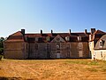
Puybautier Castle


Web links
Commons : Saint-Coutant - Collection of images, videos and audio files