
Saint-Quentin-sur-Charente
|
Saint-Quentin-sur-Charente Sent-Quentin |
||
|---|---|---|
|
||
| region | Nouvelle-Aquitaine | |
| Department | Charente | |
| Arrondissement | Confolens | |
| Canton | Charente-Vienne | |
| Community association | Charente limousine | |
| Coordinates | 45 ° 50 ′ N , 0 ° 40 ′ E | |
| height | 169-268 m | |
| surface | 14.39 km 2 | |
| Residents | 215 (January 1, 2017) | |
| Population density | 15 inhabitants / km 2 | |
| Post Code | 16150 | |
| INSEE code | 16345 | |
 Town hall (Mairie) of Saint-Quentin-sur-Charente |
||

Saint-Quentin-sur-Charente is a French municipality with 215 inhabitants (as of January 1 2017) in the department of Charente in the region Nouvelle-Aquitaine (before 2016 Poitou-Charentes ); it belongs to the Arrondissement Confolens and the canton Charente-Vienne (until 2015 Chabanais ).
geography
Saint-Quentin-sur-Charente is located about 45 kilometers east-northeast of Angoulême on the Charente , which is dammed up to form Lac de Lavaude, and is surrounded by the neighboring communities of Exideuil-sur-Vienne in the north and north-west, Chabanais in the east and north-east, Pressignac in the east, Lésignac- Durand in the south and west and Terres-de-Haute-Charente with Suris in the north-west.
Population development
| year | 1793 | 1856 | 1901 | 1962 | 1968 | 1975 | 1982 | 1990 | 1999 | 2006 | 2013 |
|---|---|---|---|---|---|---|---|---|---|---|---|
| Residents | 598 | 601 | 497 | 347 | 294 | 250 | 245 | 250 | 232 | 227 | 198 |
| Source: Cassini and INSEE | |||||||||||
Attractions
- Saint Romain Church
- Pressac Castle
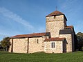
Saint Romain Church

Pressac Castle


Web links
Commons : Saint-Quentin-sur-Charente - Collection of images, videos and audio files