
Valence (Charente)
| Valence | ||
|---|---|---|
|
||
| region | Nouvelle-Aquitaine | |
| Department | Charente | |
| Arrondissement | Confolens | |
| Canton | Boixe-et-Manslois | |
| Community association | Coeur de Charente | |
| Coordinates | 45 ° 53 ' N , 0 ° 18' E | |
| height | 72-143 m | |
| surface | 10.87 km 2 | |
| Residents | 197 (January 1, 2017) | |
| Population density | 18 inhabitants / km 2 | |
| Post Code | 16460 | |
| INSEE code | 16392 | |
 Town Hall (Mairie) of Valence |
||

Valence is a French municipality with 197 inhabitants (at January 1, 2017) in the department of Charente in the region Nouvelle-Aquitaine (before 2016 Poitou-Charentes ); it belongs to the arrondissement of Confolens and the canton of Boixe-et-Manslois (until 2015 Mansle ).
geography
Valence is about thirty kilometers northeast of Angoulême . Valence is surrounded by the neighboring communities of Ventouse in the north and north-east, Cellefrouin in the east and north-east, La Tâche in the east and south-east, Saint-Mary in the south and south-east, Val-de-Bonnieure in the south and south-west and Saint-Front in the west.
Population development
| 1962 | 1968 | 1975 | 1982 | 1990 | 1999 | 2006 | 2013 |
|---|---|---|---|---|---|---|---|
| 302 | 242 | 256 | 265 | 212 | 240 | 233 | 228 |
| Source: Cassini and INSEE | |||||||
Attractions
- Saint-Pierre church from the 12th century, monument historique since 1933
- Bourgon Castle, Monument historique since 2011

Saint-Pierre church
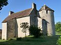
Bourgon Castle


Web links
Commons : Valence - collection of images, videos and audio files