Ambernac
| Ambernac | ||
|---|---|---|
|
|
||
| region | Nouvelle-Aquitaine | |
| Department | Charente | |
| Arrondissement | Confolens | |
| Canton | Charente-Vienne | |
| Community association | Charente limousine | |
| Coordinates | 45 ° 59 ′ N , 0 ° 33 ′ E | |
| height | 147-232 m | |
| surface | 30.05 km 2 | |
| Residents | 368 (January 1, 2017) | |
| Population density | 12 inhabitants / km 2 | |
| Post Code | 16490 | |
| INSEE code | 16009 | |
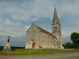
 Church Saint-Pierre |
||
Ambernac is a place and a western French community with 368 inhabitants (at January 1, 2017) in the Charente in the region Nouvelle-Aquitaine ( France ).
location
The place Ambernac is about one kilometer east of the Charente at an altitude of about 183 m above sea level. d. It is located about 55 km (driving distance) northeast of Angoulême in the old cultural landscape of the Angoumois , part of the Charente ; It is around 77 km north to Poitiers .
Population development
| year | 1800 | 1851 | 1901 | 1954 | 1999 | 2013 |
| Residents | 1.004 | 1,120 | 1,033 | 569 | 422 | 386 |
The continuous decline in population since the end of the 19th century is essentially a result of the phylloxera crisis in viticulture and the increasing mechanization of agriculture .
economy
In earlier centuries the inhabitants lived on the produce of their fields and gardens as self-sufficient ; cattle breeding was also carried out on a small scale. Viticulture has been promoted in the Charente since the end of the Middle Ages, but - despite the grapes in the local coat of arms - it never reached its previous level after the phylloxera crisis. Instead, the farmers devoted themselves again to agriculture and livestock. Agriculture, handicrafts and retail trade still play the largest role in the town's economic life. Some of the vacant houses are designated as holiday homes ( gîtes ).
history
The municipality of Ambernac belonged to the settlement area of the Celtic tribe of Lemoviks , who in 51 BC. Were subjugated by Julius Caesar . A Roman road led from Avaricum ( Bourges ) to Ecolisma (Angoulême) led through the area of the municipality; a milestone ( miliarium ) is now in the Musée d'Angoulême . In Merovingian times, coins with the word Andebrenaco were minted here. In the early Middle Ages the place belonged to the historical province of Poitou ; however, it was annexed by the Counts of Angoulême in the 11th century .
Attractions
- The Saint-Pierre church originally dates from the 13th century; However, only the eastern parts of it ( apse , a chapel and the basement of the bell tower with the accompanying stair tower ) are preserved. The new building of the single nave nave with side chapels and the upper part of the bell tower was built in 1901/02.
- Graves from Merovingian times have been discovered next to the church.
- On the outskirts there is a wash house ( lavoir ) from the 19th century.
- The two-storey Château du Plaisnaud (sometimes also Château du Praisnaud ) with a mansard roof is located about three kilometers northeast of the village ( 45 ° 59 ′ 8.9 ″ N , 0 ° 34 ′ 26 ″ E ). It dates from the 16th century; Today's residential wing ( corps de logis ) was built in the 17th century . One of the two round towers on the side is original; the other was added in the 19th century. The Landschlösschen is privately owned and has been recognized as a monument historique since 2004 .
Web links
- Ambernac, church - photos + brief information (French)
- Ambernac, church - photos + information (French)
Individual evidence
- ↑ Ambernac - Viticulture
- ↑ Château du Plaisnaud, Ambernac in the Base Mérimée of the French Ministry of Culture (French)

