
Charente (landscape)
Charente (French: sometimes Les Charentes ) is the naturalized but not officially recognized name of a landscape in south-west France . This is geographically largely identical to the present-day Charente and Charente-Maritime departments , in which the historic provinces of Saintonge , Aunis and Angoumois have merged.

geography
location
The Charente landscape includes the areas through which the Charente River flows in the north of what is now the Nouvelle-Aquitaine region with the cities of Angoulême , Cognac , Saintes and Rochefort . The cities of La Rochelle , Royan and Pons as well as the islands of Ré and Oléron also belong to the Charente. In the north, the landscape of the closing Poitou at, in the east of the Limousin , in the southeast of the Périgord and the south, the bulk of the Aquitaine basin with big cities Bordeaux and Toulouse .


landscape
The landscape of the Charente is flat to hilly. The highest peaks of only about 200 to 250 m are in the southeast on the border with the Périgord. On the coast there are dunes and maritime pine forests as well as mudflat landscapes influenced by the tides , from which marshes (marais) later developed.
climate
In large parts of the Charente, a balanced and mild climate prevails, which is largely influenced by the Atlantic , especially the Bay of Biscay . The maximum daytime temperatures in summer rarely reach values above 30 ° C; Snowfalls or even night frosts are just as rare in winter. The eastern part is a little higher and on some days is also under the climatic influence of the Massif Central . In 1999 there were hurricanes "Lothar" and "Martin", the last severe Atlantic storms to date, which also wreaked havoc in the Charente forests.
geology
The bedrock of the Charente is formed by limestone and sandstone formations that come to light in some places on the Gironde coast (e.g. near Mortagne-sur-Gironde or Talmont ). The almost white stones, broken in above and below ground quarries, were used to build churches, castles and - later - also town houses; to a small extent they were also exported by means of rafts and barges.

Infrastructure
The ports of La Rochelle, Rochefort and Royan have long linked the region with the coastal cities of Western and Northern Europe. The Autoroute A10 connects the Charentes with the Paris basin on the one hand and Bordeaux on the other; a junction ( Autoroute A837 ) connects the city of Rochefort and thus the extreme west of the Charente to the French motorway network.
Population development
While the population figures increase steadily in the cities and towns of the western Charente, holds the agrarian east, the rural exodus to - here is lacking due to the mechanization of agriculture in the workplace and the aging of the population increases.

economy
Agriculture, and especially viticulture, traditionally play the dominant role in the Charente's economic life. The Cognac wine-growing region is known all over the world; The sales figures for Cognac brandies reached record levels between 2011 and 2013. The cultivation area is largely identical to the landscape of the "Charente". The Pineau des Charentes , which is particularly popular in the region, is also made from the Charente grapes . Other traditional sources of income in the west of the Charente are fishing and oyster farming , which is carried out especially in the estuary of the Seudre ; Since the 1960s, bathing, recreational and cultural tourism have also been important economic factors. In the east, on the other hand, agricultural agriculture is predominant. A special line of business is the production of felt and paper slippers (charentaises) , which has been in operation in and around La Rochefoucauld since the 17th century , which gradually replaced the straw shoes that were worn in the house up to this time .

history
By flint finds and a few rock carvings (. Eg at Sers and Mouthiers-sur-Boëme ) is occupied, the presence of prehistoric man about 20,000 years ago. Parts of the Charente were also settled in the Neolithic Age - a number of large stone graves ( dolmens ) attest to this, but they are mostly poorly preserved because of the calcareous sandstone used; one of the most beautiful is in the area of the town of Cognac , two others near Fontenille . In the pre-Christian centuries, the Celtic tribe of the Santons lived mainly in the area around Saintes - the name of the city is derived from this. On his campaign in Gaul probably came Caesar through this region - Saintes (Mediolanum Santonum) and Fâ in Barzan ( Novioregum ) are Roman foundations. The sparse remains of two Roman funerary monuments at Authon-Ébéon and Saint-Romain-de-Benet may date from Gallo-Roman times.
In the Middle Ages, the Charente was part of the Duchy of Aquitaine and came to France with the marriage of the last heiress of the Duchy, Eleanor of Aquitaine , to the French King Louis VII in 1137. The marriage, however, remained childless and was broken even before the divorce in 1152; a few years later (1154) Eleanor married Heinrich Plantagenet , the Duke of Normandy and Count of Anjou , who became King of England that same year , so that Aquitaine was viewed by the English crown as part of their dominion. As a result, various violent conflicts arose between France and England, in which Richard the Lionheart (1157–1199), one of Eleonore's sons, was involved before participating in the Third Crusade and which ultimately resulted in the Hundred Years War (1337–1453) culminated in which large areas of the Charente were affected.


Between 1533 and 1535, John Calvin lived and taught in Angoulême, where he brought Protestant ideas to the people. This spread quickly in the region, which was independent of central France for a long time and in some ways was based on England , where King Henry VIII had also taken a separate path from the Pope and the Catholic Church in Rome in the 1530s . In many places in the Charente the proportion of the population who converted to Protestantism reached about two thirds; there were significantly more in the west of the Charente than in the east. As a result, there were permanent violent clashes with the Catholics, which culminated in the Huguenot Wars (1562–1598). The Edict of Nantes , issued by King Henry IV of France, who converted to Catholicism in 1598 , temporarily ended the disputes, granted a high degree of religious freedom and guaranteed the Protestants several safe places (places de sûreté) for a period of eight years (including also La Rochelle and Cognac), in which own garrisons were allowed to be maintained at state expense. After the assassination of Henry IV in 1610, conflicts broke out again between the two religious parties, which led Ludwig XIII, who was striving for absolute royal power . intervened in 1621. The campaign failed, however, and Louis XIII. had to confirm the Edict of Nantes issued by his father. Cardinal Richelieu , who he appointed first minister in 1624, supported the absolutist aspirations of his monarch. In 1625 the Protestants formed an army under Benjamin de Rohan , whereupon the French central power considered the need for military intervention to have come, which ended with the siege and surrender of La Rochelle (1627/28). In the Peace of Alès (1629) Protestantism was still tolerated in France, but the security posts and armies of the Protestants were abolished and Protestant fortresses had to be razed. Louis XIV continued his father's absolutist policy , which eventually led to the Edict of Fontainebleau (1685), which prohibited Protestant religious practice, prompting around a quarter of the Huguenots to emigrate. Most Protestants, however, stayed in the country and practiced their religion underground (Église du Désert) .
However, the French Revolution , which was in principle anti-religious , also enabled new freedoms in the exercise of faith, and since the 1830s, Protestant temples were built again, which also shape the face of many places in western Charente today.
Attractions
- landscape
With its rolling hills, the largely agricultural landscape of the Charente offers aspects that are well worth seeing. Almost unknown in Germany and especially popular with French holidaymakers are the west coast of the Arvert peninsula ( Côte de Beauté ) and the north-eastern shore of Gironde with the rarely overcrowded seaside resorts of La Palmyre , Saint-Palais-sur-Mer , Meschers-sur- Gironde et al. The east of the Charente, on the other hand, is more wooded and offers quiet vacation and relaxation opportunities.

Coast at La Palmyre
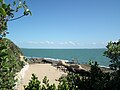
Coast at Saint-Palais-sur-Mer

Coast at Meschers-sur-Gironde
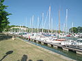
Mortagne-sur-Gironde marina

Landscape near Juignac
.JPG)


- Churches
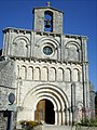
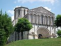
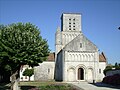
A large number of Romanesque churches form part of the Charente and especially the Saintonge and the Angoumois ; among the most beautiful are the churches of Notre-Dame (Échillais) , Ste-Radegonde de Talmont , St-Pierre d'Échebrune , Notre-Dame de Corme-Écluse , Saint-Cybard in Plassac , St-Martin in Gensac-la-Pallue and many others
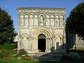
Notre-Dame in Échillais
St-Vivien in Breuillet
St-Pierre in Échebrune
Notre-Dame in Corme-Écluse


Since the 1830s, Protestant churches (temples) have been built again, which in their mostly simple architecture and furnishings are clearly different from the Catholic churches. The most elaborately designed building is that of Saint-Sulpice-de-Royan .

Temple of Matha

Temple of Breuillet

Temple of Étaules

Temple of Saint-Sulpice-de-Royan


.JPG)

- Castles
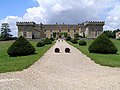
Several medieval castles and modern palaces ( châteaux ) can also be found in the Charente area. The most important are probably the donjon of Pons , the castle of La Rochefoucauld and the castle of Cognac, which was largely destroyed .
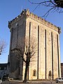
Donjon of Pons

Castle of La Léotardie near Nonac

Castle of La Rochefoucauld
Chesnel Castle in Cherves-Richemont


literature
- François Marvaud: La Charente. Répertoire archéologique du département. Le livre d'histoire, 2004
- François Marvaud: Département de la Charente: Dictionnaire historique et geographique. Le livre d'histoire, 2004
- François Eygun: Saintonge romane. Zodiaque, Saint-Léger-Vauban 1970, ISBN 2-73690-157-6 .
- Charles Daney: Les Charentes. La Renaissance du livre, 2003, ISBN 2-80460-756-9
Web links
- Tourism site of the Charente - photos + information (French)
- Website of the Charente-Maritime department - photos + information (French)
- Charente department website - photos + info (French)
Individual evidence
- ↑ La Rochelle climate diagrams
- ↑ Angoulême climate diagrams
- ↑ Cognac climate diagrams
- ↑ for the following see Ernst Mengin (ed.): The Edict of Nantes - The Edict of Fontainebleau , Gross, Flensburg 1963 and Heinz Duchhardt (ed.): The Exodus of the Huguenots: the repeal of the Edict of Nantes in 1685 as a European event. Böhlau, Cologne, Vienna 1985, ISBN 3-412-07385-7 .
- ↑ Albert Soboul: The Great French Revolution. EVA, Frankfurt 1973, p. 315ff, ISBN 3-434-00271-5