
Étaules (Charente-Maritime)
| Étaules | ||
|---|---|---|

|
|
|
| region | Nouvelle-Aquitaine | |
| Department | Charente-Maritime | |
| Arrondissement | Rochefort | |
| Canton | La Tremblade | |
| Community association | Royan Atlantique | |
| Coordinates | 45 ° 44 ′ N , 1 ° 6 ′ W | |
| height | 0-28 m | |
| surface | 11.55 km 2 | |
| Residents | 2,475 (January 1, 2017) | |
| Population density | 214 inhabitants / km 2 | |
| Post Code | 17750 | |
| INSEE code | 17155 | |
| Website | www.mairie-etaules.fr | |
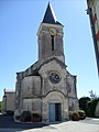
 Center of the city with a Catholic parish church. |
||

Étaules is a southwestern French municipality with 2475 inhabitants (at January 1, 2017) in the department of Charente-Maritime in the region Nouvelle-Aquitaine .
location
Étaules is located on the south bank of the Seudre , which is criss-crossed by canals, on the Arvert peninsula between Gironde and Seudre, which is part of the historic cultural landscape of the Saintonge . The next larger city is Royan (about 15 kilometers drive south).
Population development
| year | 1962 | 1968 | 1975 | 1982 | 1990 | 1999 | 2006 | 2016 |
| Residents | 1290 | 1295 | 1262 | 1316 | 1413 | 1587 | 2090 | 2398 |
In the 19th century, the place consistently had between 650 and almost 1,200 inhabitants. As a result of the mechanization of agriculture , the population decreased significantly in the first half of the 20th century and reached a low point in 1931 with 946 inhabitants.
economy
Agriculture has played a dominant role in the municipality's economic life for centuries. This is one of the Bons Bois of the Cognac wine-growing region , but because of the sales crisis for brandies, hardly any wine is grown anymore. Many farmers have returned to 'normal' agriculture. Tourism has played a not insignificant role in the economic life of the place since the 1980s. Other sources of income are fishing and oyster farming .
history
Prehistoric and Gallo-Roman finds have been made in the municipality of Étaules ; Ceramic shards were also found in an Iron Age settlement in the La pointe de Fauche district . It is believed that salt pans were also operated here for salt production. In the Middle Ages, the name of the church and the place was Sainte-Marie de L'Isle or Notre-Dame de L'Isle ; At times the church was a priory of the Abbey of La Sauve-Majeure . The first place name 'Étaules' appears in a document from 1228. The place survived the Hundred Years War (1337-1453) largely unscathed. In the middle of the 16th century, Protestantism gained more and more importance on the Arvert peninsula, as in the entire south-west of France, which led to great tensions that ultimately led to the Huguenot Wars (1562–1598). After the revocation of the Edict of Nantes (1598) by the Edict of Fontainebleau (1685), the Protestant faith, to which more than two thirds of the population in western France adhered in some parishes, continued to live underground - the faithful met secretly in the dunes or in barns; there was talk of a "church in the desert" ( Église du Desert ). Many Protestants from the southwest of France also emigrated to New France by ship . It was not until the marshal and governor Jean Charles de Saint-Nectaire , who was tolerant in religious matters , that the situation for Protestants on the Arvert peninsula improved again in the middle of the 18th century. At the end of 1793 the Revolutionary Convention resolved the freedom to practice one's religion, although a policy of de-Christianization continued and most churches were consecrated as temples of reason or remained closed until the Napoleonic era.
Attractions
- The old Catholic parish church ( Église Notre-Dame de L'Isle ), which had already been damaged in the wars of religion, burned down in 1703. With royal permission, the old building was abandoned and the stones were used to build a new church in the center of the village, which was completed in 1723 and still largely stands today. During the first years of the French Revolution , the building served as a meeting place for the village community ( maison commune ). In the middle of the 19th century, the church was renamed Notre-Dame de la Nativité and both the western and eastern parts of the church were given a new shape, which, however , was revised again in the 1950s after bombing by Allied aircraft in World War II . The nave , made of rubble stones and therefore plastered, has a low-hanging stucco vault that was applied to a wooden substructure. The transept , transept chapels , choir and apse were built after 1878 in elaborate stone carving from the light limestone of the region and each have ribbed vaults .
- The Protestants of Étaules did not have their own house of worship until the middle of the 19th century and had to move to the neighboring towns of Arvert and Chaillevette . The Protestant temple , which was built in the years 1859–1864, stands on a donated property in the center of the village. On the largely unadorned facade, which was originally raised by a small bell gable, there are classicist and neo-Romanesque elements (portal or arched frieze ). The tympanum field of the portal shows - as is usual in Protestant churches - no figurative decoration, but a spread cloth with an open book and the Bible verse "If the son sets you free, then you are really free" ( Jn 8:36 EU ).
- The three-winged mansion of the Logis de La Granderie dates from the 18th century. During the Second World War, the building briefly served as a hostel for refugees from the north and east of France. The German occupiers requisitioned the complex and destroyed the portal so that their military vehicles could drive up to the courtyard. After severe war damage, the ensemble was restored with German help in the 1950s. It is now owned by the Fondation du Protestantisme Français .
Notre-Dame church

Protestant Church

Mansion Logis de La Granderie

.JPG)

Partner communities
- Kembs , Haut-Rhin department , France
- Tengodogo , Burkina Faso
literature
- Le Patrimoine des Communes de la Charente-Maritime. Flohic Editions, Volume 2, Paris 2002, ISBN 2-84234-129-5 , pp. 1141-1144.