
Kembs
| Kembs | ||
|---|---|---|
.svg)
|
|
|
| region | Grand Est | |
| Department | Haut-Rhin | |
| Arrondissement | Mulhouse | |
| Canton | Brunstatt | |
| Community association | Saint-Louis agglomeration | |
| Coordinates | 47 ° 41 ′ N , 7 ° 30 ′ E | |
| height | 222-255 m | |
| surface | 16.45 km 2 | |
| Residents | 5,257 (January 1, 2017) | |
| Population density | 320 inhabitants / km 2 | |
| Post Code | 68680 | |
| INSEE code | 68163 | |
| Website | http://www.ville-kembs.fr | |
 Mairie Kembs |
||

Kembs (German Großkems ) is a French commune with 5257 inhabitants (as of January 1, 2017) in the Haut-Rhin department in the Grand Est region (until 2015 Alsace ).
geography
Cambete or Cambes was located on the road from Augusta Raurica to Argentovaria in Roman times and is already mentioned in the Itinerarium Antonini . Today's Kembs is located in the border triangle of Germany, France and Switzerland directly on the Canal de Huningue and the Rhine canal and is known for the Kembs hydropower plant that went into operation there in 1932 . At the confluence of the two canals is the Kembs-Niffer lock , the outer building of which was designed by the well-known architect Le Corbusier .
The neighboring communities are Rosenau in the south, Bartenheim in the southwest, Sierentz , Geispitzen and Schlierbach in the west and Niffer in the north. Kembs borders Germany in the east ; the old Rhine forms the national border there. To the right of the Rhine on the German side is the village of Kleinkems , which has been part of the Efringen-Kirchen community since 1974 .
The surrounding larger cities are Mulhouse (20 km northwest), Lörrach (30 km southeast), Saint-Louis (15 km south) and Basel (20 km south).
The districts of Schaeferhof, Loechlé and Richardshaeuser , which are south of the core town, belong to Kembs .
The Kembs -Niffer branch canal begins in Kembs .
history
From 1871 until the end of the First World War , Kembs belonged to the German Empire as part of the realm of Alsace-Lorraine and was assigned to the district of Mulhouse in the district of Upper Alsace .
Population development
| 1910 | 1962 | 1968 | 1975 | 1982 | 1990 | 1999 | 2006 | 2016 |
|---|---|---|---|---|---|---|---|---|
| 1,116 | 1,702 | 2,009 | 2.211 | 2,575 | 3,016 | 3,739 | 4.210 | 5,156 |
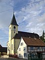
Saint-Jean-Baptiste church in Kembs

Notre-Dame-de-la-Maternité church in the Loechlé district

former Mairie (until 2014)


Kembs hydroelectric power station

Kembs water tower

Water tower in the Loechlé district


literature
- Le Patrimoine des Communes du Haut-Rhin. Flohic Editions, Volume 2, Paris 1998, ISBN 2-84234-036-1 , pp. 1124-1127.
See also
Web links
- Ville de Kembs (French)
Individual evidence
- ^ Rudolf Pörtner: With the elevator in the Roman times. Cities and sites of early German history . Econ Verlag, Düsseldorf, Vienna 1984. ISBN 3-570-09317-4 . P. 283
- ↑ Cambes . In: William Smith : Dictionary of Greek and Roman Geography. London 1854.
- ↑ Municipal directory Germany 1900 - Mülhausen district