
Bartenheim
| Bartenheim | ||
|---|---|---|
.svg)
|
|
|
| region | Grand Est | |
| Department | Haut-Rhin | |
| Arrondissement | Mulhouse | |
| Canton | Brunstatt | |
| Community association | Saint-Louis agglomeration | |
| Coordinates | 47 ° 38 ' N , 7 ° 29' E | |
| height | 237-311 m | |
| surface | 12.86 km 2 | |
| Residents | 3,837 (January 1, 2017) | |
| Population density | 298 inhabitants / km 2 | |
| Post Code | 68870 | |
| INSEE code | 68021 | |
| Website | http://www.barenheim.fr | |
 Mairie Bartenheim |
||

Bartenheim is a French commune with 3837 inhabitants (as of January 1, 2017) in the Haut-Rhin department in Alsace in the Grand Est region (until 2015 Alsace). It belongs to the canton of Brunstatt in the arrondissement of Mulhouse .
geography
The municipality of Bartenheim is located in the Upper Rhine Plain, northwest of Basel Mulhouse Freiburg Airport, on the eastern edge of the Sundgau . The district of Bartenheim-la-Chaussée also belongs to Bartenheim . The place is ten kilometers from Saint-Louis , 15 kilometers from Basel and 23 kilometers from Mulhouse .
history
From 1871 until the end of the First World War , Bartenheim belonged to the German Empire as part of the realm of Alsace-Lorraine and was assigned to the district of Mulhouse in the district of Upper Alsace .
Population development
| year | 1910 | 1962 | 1968 | 1975 | 1982 | 1990 | 1999 | 2006 | 2014 |
|---|---|---|---|---|---|---|---|---|---|
| Residents | 1,829 | 1.936 | 2.014 | 2,413 | 2,452 | 2,483 | 2,913 | 3,437 | 3.834 |
Attractions
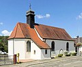
- St. George Church
- In 1803 the Chapel of Our Lady of the Fields was built at a fork in the road near the southern border of the municipality
- Chapel of St. Nicholas, built in 1860
- Chapel of St. Martin in the Bartenheim-la-Chaussée district

Church of St. Georg in Bartenheim

Chapel of Our Lady of the Fields

Chapel of St. Martin in the La Chaussée district

Monument to the fallen in the district of La Chaussée
Chapel of St. Nicholas


Transport links
Bartenheim is on the Strasbourg – Basel railway line . The station is served by the S1 line of the Basel S-Bahn and thus has direct train connections on the one hand to Mulhouse, on the other hand via Basel to Frick and Laufenburg in the Swiss canton of Aargau .
Bartenheim is on the A35 autoroute ( L'Alsacienne , junction 35). Départementsstrasse 201, which runs from the state border near Basel to the Île Napoléon, runs through the village .
literature
- Le Patrimoine des Communes du Haut-Rhin. Flohic Editions, Volume 2, Paris 1998, ISBN 2-84234-036-1 , pp. 1105-1109.
Web links
- Bartenheim on www.pays-de-sierentz.com (German)
- Bartenheim on the website of the Communauté de communes des Trois Frontières (French)