Dietwiller
| Dietwiller | ||
|---|---|---|

|
|
|
| region | Grand Est | |
| Department | Haut-Rhin | |
| Arrondissement | Mulhouse | |
| Canton | Brunstatt | |
| Community association | Mulhouse Alsace agglomeration | |
| Coordinates | 47 ° 41 ′ N , 7 ° 24 ′ E | |
| height | 240-304 m | |
| surface | 11.06 km 2 | |
| Residents | 1,447 (January 1, 2017) | |
| Population density | 131 inhabitants / km 2 | |
| Post Code | 68440 | |
| INSEE code | 68072 | |
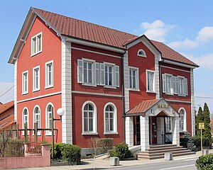
 Mairie Dietwiller |
||
Dietwiller ( German Dietweiler ) is a French commune with 1,447 inhabitants (as of January 1, 2017) in the Haut-Rhin department in the Grand Est region (until 2015 Alsace ).
The community borders in the north on Eschentzwiller , in the east on Niffer with the Forêt domaniale de la Hardt Sud , in the south on Schlierbach and in the west on Landser .
history
In 1245 the place was first mentioned as Dethwilr . Dietwiller belonged to the Landser Vogtei .
From 1871 until the end of the First World War Dietwiller belonged to the German Empire as part of the realm of Alsace-Lorraine and was assigned to the district of Mulhouse in the district of Upper Alsace .
Population development
| year | 1910 | 1962 | 1968 | 1975 | 1982 | 1990 | 1999 | 2007 | 2017 |
|---|---|---|---|---|---|---|---|---|---|
| Residents | 397 | 324 | 337 | 470 | 1053 | 1258 | 1189 | 1315 | 1447 |
Attractions
Stone houses with arched cellar entrances and half-timbered houses characterize the townscape.
The St. Nicholas Church was built in 1881. In the rear of the ship there are statues of St. Wendelin and the Virgin Mary with child. The Rinckenbach organ dates from 1891.
literature
- Le Patrimoine des Communes du Haut-Rhin. Flohic Editions, Volume 2, Paris 1998, ISBN 2-84234-036-1 , pp. 1112-1114.
Web links
- Dietwiller on pays-de-sierentz.com (French)


