Hagenthal-le-Haut
| Hagenthal-le-Haut | ||
|---|---|---|

|
|
|
| region | Grand Est | |
| Department | Haut-Rhin | |
| Arrondissement | Mulhouse | |
| Canton | Saint-Louis | |
| Community association | Saint-Louis agglomeration | |
| Coordinates | 47 ° 31 ' N , 7 ° 28' E | |
| height | 360-529 m | |
| surface | 4.92 km 2 | |
| Residents | 664 (January 1, 2017) | |
| Population density | 135 inhabitants / km 2 | |
| Post Code | 68220 | |
| INSEE code | 68121 | |
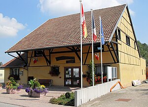
 Mairie Hagenthal-le-Haut |
||
Hagenthal-le-Haut ( German Oberhagenthal ) is a French commune with 664 inhabitants (as of January 1, 2017) in the Haut-Rhin department in the Grand Est region (until 2015 Alsace ). It belongs to the arrondissement of Mulhouse , the canton of Saint-Louis and the municipality of Saint-Louis Agglomération .
geography
The municipality of Hagenthal-le-Haut is located on the southeastern edge of the Sundgau , near the border with Switzerland , about nine kilometers northwest of Basel . The Kirchbach flows through the municipality , which from Hagenthal-le-Bas is called Lentzbach , in Swiss territory it is called Lörzbach . Hagenthal-le-Haut and the neighboring municipality of Hagenthal-le-Bas form a closed settlement area.
Neighboring communities of Hagenthal-le-Haut are Hagenthal-le-Bas in the northeast, Leymen in the southeast, Liebenswiller in the southwest, Bettlach in the west and Folgensbourg in the northwest.
Population development
| year | 1962 | 1968 | 1975 | 1982 | 1990 | 1999 | 2007 | 2017 |
| Residents | 358 | 365 | 380 | 381 | 428 | 410 | 583 | 664 |
Personalities
- Maria Franziska von Eptingen (1631–1707), abbess at Olsberg Monastery .
literature
- Le Patrimoine des Communes du Haut-Rhin. Flohic Editions, Volume 1, Paris 1998, ISBN 2-84234-036-1 , p. 613.
