Sierentz
| Sierentz | ||
|---|---|---|

|
|
|
| region | Grand Est | |
| Department | Haut-Rhin | |
| Arrondissement | Mulhouse | |
| Canton | Brunstatt | |
| Community association | Saint-Louis agglomeration | |
| Coordinates | 47 ° 39 ′ N , 7 ° 27 ′ E | |
| height | 244-301 m | |
| surface | 13.22 km 2 | |
| Residents | 3,696 (January 1, 2017) | |
| Population density | 280 inhabitants / km 2 | |
| Post Code | 68510 | |
| INSEE code | 68309 | |
| Website | http://www.mairie-sierentz.fr/ | |
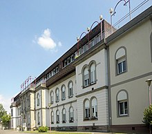
 Town hall and school building |
||
Sierentz (German Sierenz ) is a French commune with 3,696 inhabitants (as of January 1, 2017) in the Haut-Rhin department in the Grand Est region (until 2015 Alsace ). It belongs to the canton of Brunstatt and the Saint-Louis Agglomération community association .
geography
The municipality of Sierentz is located in the Upper Rhine Plain on the southwestern edge of the Harthwald between Mulhouse (23 km away) and the Swiss city of Basel (17 km away).
history
Excavations made it possible to settle the site from the Neolithic around 5000 BC. Be proven.
In the time of the Romans , two traffic routes in the east-west and north-south directions crossed in Sierentz. Thanks to them, the place developed into a well-frequented trading center.
From the 10th century, Sierentz belonged to the diocese of Basel . In 1522 the settlement passed to the Protestant Waldner von Freundstein family from Soultz , who owned it until the French Revolution .
The Dreyfus banking family, now based in Basel , has its roots in Sierentz. Her relatives were among the approximately 200 members of the Jewish community, which also had a Talmud school and a rabbinate under itself. Only remains of the synagogue remain today. Today Dreyfusplatz ( La Place Dreyfus ) in the center of the community reminds of the family .
Other former buildings are the "Hochkirch" from the 7th century, which was destroyed in 1839, an India printing house and a faience shop .
Until the 1960s there was a brick factory at the entrance to the village , the building of which is still standing today. The railway line was opened in 1840, the town hall and school building ( Mairie -école) was built in 1865.
Population development
| 1962 | 1968 | 1975 | 1982 | 1990 | 1999 | 2006 | 2016 |
|---|---|---|---|---|---|---|---|
| 1530 | 1633 | 1711 | 1666 | 2106 | 2442 | 2647 | 3685 |
Culture and sights
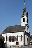
The Church of St. Martin was built in 1836. It is equipped with a statue of the crucified from the 17th century and a painting of Saint Martin . The restored organ dates from 1773.
The traditional Gasthof Saint-Laurent (formerly Gasthof Krone) was the relaxation of the Karm family until 1870 .
Regular events
The biggest festival in town is the annual harvest festival .
Economy and Infrastructure
Sierentz is the central location for the surrounding area. The local hotels and restaurants are of economic importance. Industrial companies, banks, medical practices and small businesses are also well represented.
In the 400 kV substation , electrical energy for Germany, France and Switzerland is traded.
Thanks to the good economic situation, the villagers were nicknamed "Däusiger". This is Alsatian dialect and means “thousands”.
traffic
Sierentz is on the Strasbourg – Basel railway line and the A35 autoroute (junction 34). The station is served by the S1 line of the Basel S-Bahn and thus has direct train connections on the one hand to Mulhouse, on the other hand via Basel to Frick and Laufenburg in the Swiss canton of Aargau .
Personalities
- Klaus Jürgen Bade (* 1944), German historian
- Jean-Marie Zoellé (1944–2020), politician and mayor of Saint-Louis
- Mito Loeffler (1961–2011), jazz guitarist
See also
- Meister von Sierentz , emergency name of a German late Gothic painter who worked on the Upper Rhine around 1445–50
literature
- Le Patrimoine des Communes du Haut-Rhin. Flohic Editions, Volume 2, Paris 1998, ISBN 2-84234-036-1 , pp. 1145-1155.


