
Relay fields
| Relay fields | ||
|---|---|---|
.svg)
|
|
|
| region | Grand Est | |
| Department | Haut-Rhin | |
| Arrondissement | Mulhouse | |
| Canton | Wittenheim | |
| Community association | Mulhouse Alsace agglomeration | |
| Coordinates | 47 ° 50 ′ N , 7 ° 15 ′ E | |
| height | 238-270 m | |
| surface | 7.42 km 2 | |
| Residents | 3,959 (January 1, 2017) | |
| Population density | 534 inhabitants / km 2 | |
| Post Code | 68850 | |
| INSEE code | 68321 | |
 Mairie Staffelfelden |
||

Staffelfelden is a French commune with 3959 inhabitants (as of January 1, 2017) in the Haut-Rhin department in the Grand Est region ( Alsace until 2015 ). It belongs to the arrondissement of Mulhouse and the canton of Wittenheim .
geography
The former mining community of Staffelfelden lies on both sides of the Thur , around eight kilometers northwest of Mulhouse . The Cité Rossallmend district was created as a workers' settlement for the workers of the Marie-Louise potash mine , which was closed in 2002.
history
From 1871 until the end of the First World War , Staffelfelden belonged to the German Empire as part of the realm of Alsace-Lorraine and was assigned to the Thann district in the Upper Alsace district .
Population development
| 1910 | 1962 | 1968 | 1975 | 1982 | 1990 | 1999 | 2006 | 2017 |
|---|---|---|---|---|---|---|---|---|
| 253 | 3164 | 3234 | 3513 | 3465 | 3331 | 3553 | 3.79 | 3959 |
Attractions
- St. Gallus Church ( Église Saint-Gall )
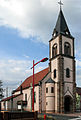
Southwest side of the St. Gallus Church

Northeast side of St. Gallus Church

Church of St. Peter and Paul in the Cité Rossallmend estate


literature
- Le Patrimoine des Communes du Haut-Rhin. Flohic Editions, Volume 1, Paris 1998, ISBN 2-84234-036-1 , pp. 155-157.