
Reiningue
| Reiningue | ||
|---|---|---|
.svg)
|
|
|
| region | Grand Est | |
| Department | Haut-Rhin | |
| Arrondissement | Mulhouse | |
| Canton | Kingersheim | |
| Community association | Mulhouse Alsace agglomeration | |
| Coordinates | 47 ° 45 ′ N , 7 ° 14 ′ E | |
| height | 255-297 m | |
| surface | 18.54 km 2 | |
| Residents | 1,981 (January 1, 2017) | |
| Population density | 107 inhabitants / km 2 | |
| Post Code | 68950 | |
| INSEE code | 68267 | |
| Website | http://www.mairie-reiningue.fr/ | |
 Mairie Reiningue |
||

Reiningue (German Reiningen ) is a French commune with 1981 inhabitants (January 1, 2017) in the Haut-Rhin department in the Grand Est region (until 2015 Alsace ). It belongs to the arrondissement of Mulhouse and the canton of Kingersheim .
geography
The municipality of Reiningue is located between Mulhouse and the Vosges on the Doller , a few kilometers from its confluence with the Ill . Large parts of the municipal area of 18.5 km² are used for agriculture, in the north-west there is an approximately 350 hectare contiguous forest area that belongs to the Bois de Nonnenbruch forest .
Neighboring communities of Reiningue are Wittelsheim in the north, Lutterbach in the east, Morschwiller-le-Bas in the southeast, Heimsbrunn in the south and Schweighouse-Thann in the west.
history
From 1871 until the end of the First World War , Reiningue belonged to the German Empire as part of the realm of Alsace-Lorraine and was assigned to the district of Mulhouse in the district of Upper Alsace .
Population development
| year | 1910 | 1962 | 1968 | 1975 | 1982 | 1990 | 1999 | 2007 | 2017 |
|---|---|---|---|---|---|---|---|---|---|
| Residents | 1,350 | 1,500 | 1,536 | 1,759 | 1,701 | 1,683 | 1,630 | 1,705 | 1,981 |
Attractions
- Cistercian Abbey Notre-Dame d'Oelenberg from the 11th century
- Parish church of Saint-Romain, rebuilt in place of a previous building at the end of the 17th century, reconstructed in 1923, restored in 1953
- Deckwiller Chapel from 1931, reminiscent of the village of Deckwiller, which perished in the 16th century
- Water tower on the Rue du Schweighouse
- Quarry pond ( Plan d'eau de Reiningue ) with tourist infrastructure

Oelenberg Abbey
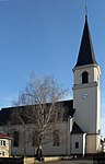
Parish Church of Saint-Romain

Deckwiller Chapel
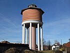
Water tower


Transport links
Due to its proximity to the city of Mulhouse, Reiningue is well connected to national transport routes. The A 36 ( La Comtoise ) runs south and the national road N 66 north-east of Reiningue.
literature
- Le Patrimoine des Communes du Haut-Rhin. Flohic Editions, Volume 2, Paris 1998, ISBN 2-84234-036-1 , pp. 1375-1378.
Web links
Individual evidence
- ↑ Municipal directory Germany 1900 - Mülhausen district
- ↑ Entry on patrimoine-de-france.org. (No longer available online.) Formerly in the original ; Retrieved April 1, 2011 (French). ( Page no longer available , search in web archives ) Info: The link was automatically marked as defective. Please check the link according to the instructions and then remove this notice.