
Richwiller
| Richwiller | ||
|---|---|---|
.svg)
|
|
|
| region | Grand Est | |
| Department | Haut-Rhin | |
| Arrondissement | Mulhouse | |
| Canton | Kingersheim | |
| Community association | Mulhouse Alsace agglomeration | |
| Coordinates | 47 ° 47 ' N , 7 ° 17' E | |
| height | 239-259 m | |
| surface | 5.55 km 2 | |
| Residents | 3,689 (January 1, 2017) | |
| Population density | 665 inhabitants / km 2 | |
| Post Code | 68120 | |
| INSEE code | 68270 | |
 Town Hall (Mairie) |
||

Richwiller ( German Reichweiler ) is a French commune with 3,689 inhabitants (as of January 1, 2017) in the Haut-Rhin department in the Grand Est region (until 2015 Alsace ). It belongs to the arrondissement of Mulhouse and the canton of Kingersheim .
geography
The community of Richwiller is five kilometers northwest of Mulhouse . The community consists of three parts: the original village on the road from Pfastatt to Wittelsheim, part of the former miners' settlement Cité Amélie to the west and a large industrial area in the northeast in the direct vicinity of Kingersheim. In the west, the municipality has a share in the Bois de Nonnenbruch , a forest area with numerous ponds.
Neighboring communities of Richwiller are Wittenheim in the northeast, Kingersheim in the east, Pfastatt in the south and Wittelsheim in the west.
Population development
| year | 1962 | 1968 | 1975 | 1982 | 1990 | 1999 | 2007 | 2016 |
|---|---|---|---|---|---|---|---|---|
| Residents | 2309 | 2352 | 2655 | 2938 | 3150 | 3325 | 3374 | 3687 |
Attractions
- Church of St. Catherine ( Sainte-Catherine ), consecrated in 1876
- Christ-Roi Church (Christ the King's Church) in the miners' settlement Cité Amélie II
 Church of St. Catherine
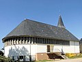 Christ the King Church


literature
- Le Patrimoine des Communes du Haut-Rhin. Flohic Editions, Volume 2, Paris 1998, ISBN 2-84234-036-1 , pp. 1379-1383.