
Saint-Jean-d'Angle
| Saint-Jean-d'Angle | ||
|---|---|---|

|
|
|
| region | Nouvelle-Aquitaine | |
| Department | Charente-Maritime | |
| Arrondissement | Rochefort | |
| Canton | Marennes | |
| Community association | Rochefort Ocean | |
| Coordinates | 45 ° 49 ′ N , 0 ° 57 ′ W | |
| height | 2-32 m | |
| surface | 21.61 km 2 | |
| Residents | 693 (January 1, 2017) | |
| Population density | 32 inhabitants / km 2 | |
| Post Code | 17620 | |
| INSEE code | 17348 | |
 View of the town of Saint-Jean-d'Angle |
||

Saint-Jean-d'Angle is a French municipality with 693 inhabitants (as of January 1 2017) in the department of Charente-Maritime in the region Nouvelle-Aquitaine . The municipality belongs to the arrondissement of Rochefort and the canton of Marennes (until 2015: canton of Saint-Agnant ). The inhabitants are called Anglois .
geography
Saint-Jean-d'Angle is located in the salt marshes of the historic Saintonge landscape . The river Arnaise limits the municipality to the east. Saint-Jean-d'Angle is surrounded by the neighboring communities of Saint-Agnant in the north, Champagne in the east, La Gripperie-Saint-Symphorien in the south, Saint-Just-Luzac in the south-west and Marennes-Hiers-Brouage in the west and north-west.
Population development
| 1962 | 1968 | 1975 | 1982 | 1990 | 1999 | 2006 | 2013 | |
|---|---|---|---|---|---|---|---|---|
| 442 | 456 | 431 | 464 | 486 | 510 | 534 | 677 | |
| Source: Cassini and INSEE | ||||||||
Attractions
See also: List of Monuments historiques in Saint-Jean-d'Angle
- 11th century Saint-Jean-Baptiste church
- Medieval town center
- Castle ruins of Saint-Jean-d'Angle, Monument historique
- Market hall , built in the 17th century (Monument historique)
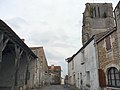
Church and street in the center

Saint-Jean-d'Angle Castle

Market hall


literature
- Le Patrimoine des Communes de la Charente-Maritime. Flohic Editions, Volume 2, Paris 2002, ISBN 2-84234-129-5 , pp. 809-811.