
Saint-Hippolyte (Charente-Maritime)
| Saint-Hippolyte | ||
|---|---|---|
|
||
| region | Nouvelle-Aquitaine | |
| Department | Charente-Maritime | |
| Arrondissement | Rochefort | |
| Canton | Tonnay-Charente | |
| Community association | Rochefort Ocean | |
| Coordinates | 45 ° 55 ′ N , 0 ° 54 ′ W | |
| height | 1–27 m | |
| surface | 23.28 km 2 | |
| Residents | 1,416 (January 1, 2017) | |
| Population density | 61 inhabitants / km 2 | |
| Post Code | 17430 | |
| INSEE code | 17346 | |
| Website | http://www.saint-hippolyte.fr/ | |
 Town hall (Mairie) of Saint-Hippolyte |
||

Saint-Hippolyte is a French commune with 1,416 inhabitants (as of January 1 2017) in the department of Charente-Maritime in the region Nouvelle-Aquitaine . Saint-Hippolyte belongs to the Arrondissement of Rochefort and the Canton of Tonnay-Charente . The inhabitants are called Hippolytains .
geography
Saint-Hippolyte is located about five kilometers east-southeast of the city center of Rochefort on the Charente , which borders the municipality in the north. Saint-Hippolyte is surrounded by the neighboring communities of Tonnay-Charente in the north, Cabariot in the east and northeast, La Vallée in the east and southeast, Trizay in the south, Échillais in the southwest and Rochefort in the west.
Population development
| year | 1962 | 1968 | 1975 | 1982 | 1990 | 1999 | 2006 | 2013 |
|---|---|---|---|---|---|---|---|---|
| Residents | 827 | 858 | 809 | 969 | 1.109 | 1,121 | 1,244 | 1,396 |
| Source: Cassini and INSEE | ||||||||
Attractions
See also: List of Monuments historiques in Saint-Hippolyte (Charente-Maritime)
- Saint-Hippolyte church from the 12th century, renovations from the 15th century, monument historique since 1995
- La Bergerie castle ruins
- Locks
- Arch bridge
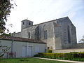
Saint-Hippolyte Church

La Bergerie castle ruins
.jpg)

literature
- Le Patrimoine des Communes de la Charente-Maritime. Flohic Editions, Volume 2, Paris 2002, ISBN 2-84234-129-5 , p. 1127.