
Saint-Denis-d'Oléron
| Saint-Denis-d'Oléron | ||
|---|---|---|
.svg)
|
|
|
| region | Nouvelle-Aquitaine | |
| Department | Charente-Maritime | |
| Arrondissement | Rochefort | |
| Canton | Île d'Oléron | |
| Community association | Île d'Oléron | |
| Coordinates | 46 ° 2 ′ N , 1 ° 23 ′ W | |
| height | 0-15 m | |
| surface | 11.75 km 2 | |
| Residents | 1,320 (January 1, 2017) | |
| Population density | 112 inhabitants / km 2 | |
| Post Code | 17650 | |
| INSEE code | 17323 | |
| Website | http://www.st-denis-oleron.com/cadre/denifram.html | |
 Coast at Saint-Denis-d'Oléron |
||

Saint-Denis-d'Oléron is a western French community with 1,320 inhabitants (as of January 1 2017) in the department of Charente-Maritime in the region Nouvelle-Aquitaine . The municipality belongs to the arrondissement of Rochefort and the canton of Île d'Oléron (until 2015: canton of Saint-Pierre-d'Oléron ). The inhabitants are called Dionysia .
geography
Saint-Denis-d'Oléron is located in the very north of the Île d'Oléron , the second largest French island. Saint-Denis-d'Oléron is surrounded by the neighboring communities of La Brée-les-Bains in the southeast and Saint-Georges-d'Oléron in the south. The community also surrounds the Atlantic coast.
Population development
| year | 1962 | 1968 | 1975 | 1982 | 1990 | 1999 | 2006 | 2017 |
| Residents | 896 | 901 | 951 | 1004 | 1107 | 1221 | 1172 | 1320 |
| Sources: Cassini and INSEE | ||||||||
Attractions
See also: List of the Monuments historiques in Saint-Denis-d'Oléron
- Saint-Denys church from the 17th century, monument historique since 1896
- priory
- Mills
- Chassiron lighthouse
- Marina
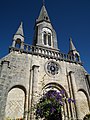
Saint-Denys church

Charisson lighthouse

Port and marina


literature
- Le Patrimoine des Communes de la Charente-Maritime. Flohic Editions, Volume 2, Paris 2002, ISBN 2-84234-129-5 , pp. 922-924.