
Île d'Oléron
| Île d'Oléron | ||
|---|---|---|
 |
||
| Waters | Bay of Biscay | |
| Geographical location | 45 ° 56 ′ N , 1 ° 17 ′ W | |
|
||
| length | 34 km | |
| width | 12 km | |
| surface | 174 km² | |
| Highest elevation | Grande dune de Saint-Trojan 34 m |
|
| Residents | 22,203 (January 1, 2017) 128 inhabitants / km² |
|
| main place | Saint-Pierre-d'Oléron | |
 |
||

The Île d'Oléron is the second largest French island in Europe. It is located in the Atlantic Ocean and belongs to the Charente-Maritime department and the Nouvelle-Aquitaine region and is also known as the " Mimosa Island ".
geography
The Île d'Oléron is located on the French west coast on the Atlantic Ocean or on the Bay of Biscay north of the Gironde estuary near the port city of Rochefort . Oléron and the neighboring island of Île de Ré together with the mainland enclose the Pertuis d'Antioche , a stretch of sea that is considered a paradise for sailors . Its southern area is largely silted up and thus offers ideal terrain for mussel and oyster farming . Due to the good conditions and the continuous inflow of fresh water, the island has become one of the most important regions for oyster farming in Europe.
The island is 34 km long and 12 km wide at its widest point. Leaving the overseas departments out of consideration, it is the second largest French island after Corsica , with an area of 175 km², and the largest on the Atlantic coast before Belle-Île and Île de Ré .
There are no noteworthy surveys.
traffic
Like the Île de Ré, the island is connected to the mainland by a bridge. The 2862 m long Viaduc d'Oléron , which connects Bourcefranc-le-Chapus with the south of the island, was the longest bridge in France when it opened in 1966. In 1992 the toll for the viaduct was abolished. There was a ferry at this point until the bridge was built. As a remnant of the ferry traffic, one can still see the two long ferry piers, which are closed to the public, leading to the tide-independent fairway.
There are only country roads on the island itself. The main connections, but also an increasing number of secondary lines, are usually well developed. Nowadays there is a well-developed network of cycle paths on the predominantly flat island. In the south of the island there is a light railway with passenger traffic.
Regional buses run several times a day between Surgères, Rochefort, Marennes and the Île d'Oléron, serving at least Le Château, Dolus and Saint-Pierre on the island. In Surgères, the buses have targeted connections to TGV trains to and from Paris. There are also individual bus connections to La Rochelle, and during the summer holidays to Saintes. During the summer holidays, free shuttle buses also regularly commute on five routes to all places on the Île d'Oléron.
On April 24, 1904, a railway line was put into operation on the Île d'Oléron. However, passenger traffic was discontinued in 1934 and goods traffic in 1935. On the main line from Saint-Trojan via Saint-Pierre to Saint-Denis there were 25 stations or stops, and there was a branch line to Boyardville with three other stations. Buses have been operating on the island since 1927.
The ports are almost exclusively used for private and tourist trips. In season, liner ships operate to the neighboring island of Île-d'Aix , La Rochelle , Fort Boyard and Île de Ré . One of the most important fishing ports on the French Atlantic coast is located in La Cotinière.


administration

The island belongs to the Nouvelle-Aquitaine region , the Charente-Maritime department and the Rochefort arrondissement . The Île d'Oléron has a permanent population of 22,203 (as of January 1, 2017).
The island is congruent with the canton Île d'Oléron ( capital : Saint-Pierre-d'Oléron ) and is divided into eight municipalities:
- La Brée-les-Bains
- Le Château-d'Oléron
- Dolus-d'Oléron
- Le Grand-Village-Plage
- Saint-Denis-d'Oléron
- Saint-Georges-d'Oléron
- Saint-Pierre-d'Oléron
- Saint-Trojan-les-Bains
tourism
Due to its mild climate, the island is very popular with tourists from April to mid-September at the latest. Excursion destinations include the Phare de Chassiron lighthouse built between 1834 and 1836, Fort Boyard , which is known from television broadcasts and upstream near Boyardville, and the Citadelle du Château d'Oléron built under Vauban. In the Bastion de la Brèche there is a military history museum that provides information about the French colonization of North America and the cultures of the First Nations .
The open-air museum Port des Salines in Petit-Village, a district of Le Grand Village Plage, documents the craft of sea salt extraction.
The Marais aux Oiseaux marshland is home to around 60 species of animals that are otherwise rarely seen in nature.
There are pure sandy beaches in the north and south-west of the island; in the middle stony passages alternate with sprinkling sand along the surf line. These beaches are guarded by lifeguards during the season. On the east side, facing the mainland, there is also an approx. 15 km long sandy beach from Boyardville to the port of La Brée.
The forest and dune area at Grand-Village and Saint-Trojan is a nature reserve.
In some villages there are regular weekly and flea markets; Saint-Pierre and La Cotinière in particular offer island specialties.


Phare de Chassiron

Le Port des Salines

The salt fields of Port des Salines

Viaduc d'Oléron
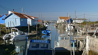
Oyster farming on the Île d'Oléron

Oléron oysters
.jpg)


history

The island was already known under the name Ularius in Roman times and, according to Pliny, served as a summer resort. In later centuries, like many of the other Atlantic islands, it was a point of contention between France and England. The powerful Duchess of the Middle Ages and queen of two countries, Eleanor of Aquitaine , spent 16 years of her life in captivity on Oléron for supporting the rebellions of her eldest sons against her husband Henry II . During this time, the Rôles d'Oléron code of maritime law, named after the island and kept there, was written down.
In the 16th century the island population was predominantly Huguenot . 1623 took Louis XIII. owned the island. Carl Constantin von Hessen-Rheinfels-Rotenburg was exiled to the island from 1800 to 1803 after the assassination attempt with the so-called hell machine on Napoléon Bonaparte. During the German occupation in World War II , the island was part of the Atlantic Wall ; Even today there are old bunkers and defenses on some beaches and in the dunes. The writer Pierre Loti , who was born opposite in the port city of Rochefort , spent most of his life on the island . He emphasized the special character of the bright light on Oléron and described the island in parts of his works.