Belle-Île
| Belle-Île | ||
|---|---|---|
| Belle-Île-en-Mer island | ||
| Waters | Atlantic Ocean | |
| Archipelago | Breton Islands | |
| Geographical location | 47 ° 19 '36 " N , 3 ° 10' 54" W | |
|
|
||
| surface | 87 km² | |
| Highest elevation | Croix du Run 71 m |
|
| Residents | 5120 59 inhabitants / km² |
|
| main place | Le Palais | |
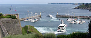
| Departure of the fast ferry from the port of Le Palais | ||
Belle-Île-en-Mer (old spelling: Belle Isle , Breton : Enez ar Gerveur ) is located south of Lorient and is the largest of the Breton islands .
The island belongs to the Morbihan department , is 87 km² and in 1876 had 11,000 inhabitants. It is located 14 km from Quiberon. The highest point is 71 m at the Croix du Run ( location ). The island is surrounded by rocks, but the interior is rich in fertile pastures and arable land. The inhabitants practiced agriculture, horse breeding, fishing (especially anchovy fishing), salt slurrying, trading in grain, cattle and fish. The capital is the port Le Palais (Bret. Porzh Lae ), which is dominated by the image of the pyramidal citadel, which was expanded by Vauban at the end of the 17th century .
The four parishes on the island are Le Palais , Sauzon , Bangor and Locmaria . The menhirs Jean and Jeanne are 340 m apart, east of the village of Kerlédan.
Charles IX gave the island to Marshal von Retz as marquisate, whose son sold it in 1658 to the finance manager Fouquet , who had it fortified. His grandson was the famous Marshal Charles Louis Auguste Fouquet de Belle-Isle , who ceded the island to the Crown for County Gisors in 1718.

At Belle-Île, the British fleet under Vice Admiral Sir Edward Hawke was victorious over the French under Conflans on November 20, 1759 in the naval battle in the Bay of Quiberon .
Until 1977, the island housed an infamous penal camp for minors.
On Belle-Ile is the lighthouse Goulphar ( location ), which was put into service. 1835 In the lighthouse and its annex is the administration for the tanning of the entire French Atlantic coast.
Today the island has around 5,120 (as of 2008) inhabitants, but in summer it hosts around 20,000 holidaymakers. The tourism has become one of the main sources of income.
Grotte de l'Apothicairerie
In the 1970s and 1980s, it was considered a major tourist attraction in Brittany. It is closed today. One descended on a staircase carved into the rock with slippery steps. In front of the entrance on the left side was the arch "Roche Percée", which collapsed in 1975.
Sources and individual references
- ↑ anars56: Un bagne pour enfants à Belle-Ile. Retrieved July 20, 2019 (French).
Web links
- Belle-Île website
- Belle Ile Citadel
- Compagnie Oceane - ferry business for the crossing to Belle Ile
- Belle-Île in Brittany: Inkblot in the Atlantic , article by Ulrike Koltermann in Spiegel Online , April 18, 2012


