Bangor (Morbihan)
| Bangor | ||
|---|---|---|
|
|
||
| region | Brittany | |
| Department | Morbihan | |
| Arrondissement | Lorient | |
| Canton | Quiberon | |
| Community association | Belle-Île-en-Mer | |
| Coordinates | 47 ° 19 ′ N , 3 ° 11 ′ W | |
| height | 0-58 m | |
| surface | 25.54 km 2 | |
| Residents | 999 (January 1, 2017) | |
| Population density | 39 inhabitants / km 2 | |
| Post Code | 56360 | |
| INSEE code | 56009 | |
| Website | http://www.bangor.fr/ | |
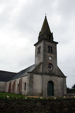
 Church of St. Peter and Paul |
||
Bangor ( Breton Bangor ) is a French municipality with 999 inhabitants (1 January 2017) in the department of Morbihan in the region of Brittany .
The municipality in the Breton-speaking region belongs to the canton of Belle-Île in the Arrondissement of Lorient and is a member of the Belle-Île-en-Mer municipal association .
geography
Bangor is located in the southwest of the island of Belle-Île-en-Mer in the Atlantic at an altitude between zero and 58 m above sea level. The municipality of Bangor includes some offshore rock islands ( Île de Bangor, Îles Baguenères ). The island's airfield ( Aérodrome de Belle-Île-en-Mer ) is in the north of the municipal area.
Population development
| year | 1962 | 1968 | 1975 | 1982 | 1990 | 1999 | 2008 |
| Residents | 578 | 550 | 563 | 637 | 735 | 738 | 910 |
Attractions
See also: List of Monuments historiques in Bangor (Morbihan)
- Church of St. Peter and Paul ( Église Saint-Pierre et Saint-Paul )
- Menhir La Pierre Sainte Anne
- Phare de Goulphar (lighthouse)
literature
- Le Patrimoine des Communes du Morbihan. Flohic Editions, Volume 1, Paris 1996, ISBN 2-84234-009-4 , pp. 127-129.
Web links
Commons : Bangor - collection of pictures, videos and audio files

