
Inguiniel
|
Inguiniel An Ignel |
||
|---|---|---|
|
||
| region | Brittany | |
| Department | Morbihan | |
| Arrondissement | Lorient | |
| Canton | Guidel | |
| Community association | Lorient agglomeration | |
| Coordinates | 47 ° 59 ′ N , 3 ° 17 ′ W | |
| height | 49-171 m | |
| surface | 51.40 km 2 | |
| Residents | 2,158 (January 1, 2017) | |
| Population density | 42 inhabitants / km 2 | |
| Post Code | 56240 | |
| INSEE code | 56089 | |
| Website | https://www.inguiniel.fr/mairie/ | |
 The village center (Bourg) of Inguiniel |
||

Inguiniel ( bret. : At Ignel ) is a French municipality with 2158 inhabitants (as of January 1 2017) in the department of Morbihan in the region of Brittany . The municipality belongs to the arrondissement of Lorient and the canton of Guidel (until 2015: canton of Pluvigner ).
geography
Inguiniel is located in the interior of the Morbihan department. In the north the river [Scorff] forms the municipality boundary. The small town of Pontivy is about 25 kilometers to the northeast, the city of Lorient is about 30 km to the south.
history
The place has been inhabited since the Iron Age. Remains of a Gallic village from the 1st century came to light during excavations in Kervern-Teignousse. Historically, it is part of the Breton region of Pays Pourlet (Breton: Bro Pourlet ). A first monastery was founded in Moustoir. The monastery was destroyed in a Norman invasion in the 10th century. In the Middle Ages Inguiniel was an important parish that was responsible for pastoral care in several places. After the French Revolution it was a battle zone between Republican troops and the Chouans. Politically, Inguiniel became a municipality in 1790. From 1793 Inguiniel belonged to the Canton of Bubry and the District of Hennebont. From 1801 it was part of the Lorient arrondissement and from 1801 to 2015 a municipality in the canton of Plouay .
Population development
Between 1793 and 1946 the population grew more and more - with small, temporary fluctuations downwards - and reached its historical peak in 1946 with 2,868 inhabitants. Then a wave of emigration began, which only stopped in 1999 (1946–1999: -35%). Since then, the number of residents has increased slightly again and is now over 2,000 residents again. The development:
| year | 1793 | 1946 | 1962 | 1968 | 1975 | 1982 | 1990 | 1999 | 2006 | 2012 |
| Residents | 2,027 | 2,868 | 2,552 | 2,309 | 2.115 | 2,030 | 1,968 | 1,890 | 2.011 | 2,069 |
Attractions
See also: List of Monuments historiques in Inguiniel
- Kerascouet Castle (also Kerascoët)
- Manor house of Brezehan (also Brézéhan; 13th-15th centuries)
- Saint-Alban village church, built in 1777
- Notre-Dame de Locmaria chapel from 1468
- Chapels of Lochrist (17th century) and Saint-Claude (18th century; with Calvaire )
- Rectory on Place des Tilleuls from 1694
- Cross of Pont-er-len (from 1675)
- Spring and the public wash house (Lavoir)
- long farmhouse in Le Guaingair (18th century)
- Stele from Kervern-Teignousse (5th century BC)
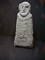
Pre-Christian Gallic stele

Notre-Dame de Locmaria chapel

Chapel of Saint-Claude

Calvaire in Lochrist

_Chapelle_de_Locmaria_01.JPG)
_3719.JPG)
_Calvaire_de_Lochrist.JPG)
literature
- Le Patrimoine des Communes du Morbihan. Flohic Editions, Volume 2, Paris 1996, ISBN 2-84234-009-4 , pp. 678-680.
Individual evidence
- ↑ Sights of the community ( Memento of the original from April 2, 2015 in the Internet Archive ) Info: The archive link was inserted automatically and has not yet been checked. Please check the original and archive link according to the instructions and then remove this notice.