Île-d'Houat
|
Île-d'Houat Enez Houad |
||
|---|---|---|

|
|
|
| region | Brittany | |
| Department | Morbihan | |
| Arrondissement | Lorient | |
| Canton | Quiberon | |
| Community association | Auray Quiberon Terre Atlantique | |
| Coordinates | 47 ° 23 ′ N , 2 ° 57 ′ W | |
| height | 0-42 m | |
| surface | 2.91 km 2 | |
| Residents | 231 (January 1, 2017) | |
| Population density | 79 inhabitants / km 2 | |
| Post Code | 56170 | |
| INSEE code | 56086 | |
| Website | www.mairiedehouat.fr | |
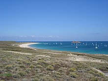
 Aerial view of the island |
||
The Ile-d'Houat ( Breton Enez Houad ) is a French island and a community with 231 inhabitants (at January 1, 2017) in the Morbihan department in the region of Brittany .
The almost three square kilometers large island is located in the Bay of Quiberon , at the entrance to the Gulf of Morbihan .
The island can be reached by boat from Quiberon or from Vannes by catamarans . The island port is Port-Saint-Gildas, a small fishing village. The inhabitants of the island are called Houatais.
description
The dune beach Treach-er-Goured and the viewpoint Beg-er-Vachif are worth seeing. On the island are the menhirs Menhir de Bar-Kreiz, Menhir de Men-Guen, Menhir von Parc-er-Menhir , Menhir du Stade and the Menhirs de Men-Plat. The island is the setting for the crime novel "The Portrait" by the English writer Iain Pears .
The Belle-Île and the Île d'Hœdic are in the neighborhood . Presumably, the island is identical to the island named Siata in ancient geography .
The island forms the municipality of the same name. Most of the population lives in the village in the northeast of the island. The rest of the island is sparsely developed and uninhabited in winter.
The tidal island Er Yoc'h lies off the east coast . The Île aux Chevaux is located off the south coast
| year | 1962 | 1968 | 1975 | 1982 | 1990 | 1999 | 2007 |
| Residents | 446 | 457 | 430 | 390 | 390 | 335 | 293 |
See also
literature
- N. Forrer, W. Wirth: The island of Houat . In: Mitteilungen der Geographisch-Ethnographische Gesellschaft Zürich, Volume 26 (1925–1926), pp. 19–34 ( digitized version )
- Le Patrimoine des Communes du Morbihan. Flohic Editions, Volume 2, Paris 1996, ISBN 2-84234-009-4 , pp. 842-845.
Web links
- Île-d'Houat commune (French)
Individual evidence
- ^ Itinerarium Antonini Augusti maritimum 510.1. See also George Long: Siata . In: William Smith : Dictionary of Greek and Roman Geography. London 1854.
- ↑ Île-d'Houat on the Insee website


