Plouharnel
| Plouharnel | ||
|---|---|---|
|
|
||
| region | Brittany | |
| Department | Morbihan | |
| Arrondissement | Lorient | |
| Canton | Quiberon | |
| Community association | Auray Quiberon Terre Atlantique | |
| Coordinates | 47 ° 36 ′ N , 3 ° 7 ′ W | |
| height | 0-33 m | |
| surface | 18.32 km 2 | |
| Residents | 2,160 (January 1, 2017) | |
| Population density | 118 inhabitants / km 2 | |
| Post Code | 56340 | |
| INSEE code | 56168 | |
| Website | mairie.plouharnel.fr | |
 Chapel of Sainte-Barbe |
||
Plouharnel is a French commune with 2,160 inhabitants (at January 1, 2017) in the department of Morbihan in the region of Brittany . It is located in the north of the Quiberon Bay, three kilometers from Carnac . Vannes , the seat of the prefecture , is just 40 km to the east. The largest dune area in France is located near Plouharnel .
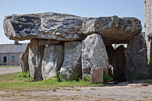
In the area of the commune there are numerous menhirs and other evidence from the Neolithic , as they are common in Brittany. The three dolmens of Rondossec are located on Rue Hoche in Plouharnel .
The Plouharnel-Carnac station is on the Auray – Quiberon railway line . The La Trinité – Étel tram ran through the town until 1935.
On July 16, 1795, the battle at Plouharnel took place here.
Population development
| year | 1962 | 1968 | 1975 | 1982 | 1990 | 1999 | 2008 |
|---|---|---|---|---|---|---|---|
| Residents | 1,478 | 1,487 | 1,492 | 1,525 | 1,653 | 1,699 | 1,962 |
Attractions
See: List of Monuments historiques in Plouharnel
literature
- Le Patrimoine des Communes du Morbihan. Flohic Editions, Volume 2, Paris 1996, ISBN 2-84234-009-4 , pp. 845-847.
Web links
- Municipality of Plouharnel (French)
- Plouharnel Tourist Office (French, English, German)

