
Brandérion
|
Brandérion Prederion |
||
|---|---|---|
.svg)
|
|
|
| region | Brittany | |
| Department | Morbihan | |
| Arrondissement | Lorient | |
| Canton | Pluvigner | |
| Community association | Lorient agglomeration | |
| Coordinates | 47 ° 48 ′ N , 3 ° 12 ′ W | |
| height | 8-79 m | |
| surface | 6.03 km 2 | |
| Residents | 1,429 (January 1, 2017) | |
| Population density | 237 inhabitants / km 2 | |
| Post Code | 56700 | |
| INSEE code | 56021 | |
| Website | www.branderion.com | |
 The Sainte-Anne chapel in Brandérion |
||

Brandérion ( Breton : Prederion ) is a French municipality with 1429 inhabitants (as of January 1 2017) in the department of Morbihan in the region of Brittany . The municipality belongs to the arrondissement of Lorient and the canton of Pluvigner .
geography
Brandérion is located inland in the west of the Morbihan department. The village is located about 15 kilometers southwest of the city of Lorient . Neighboring communities are Languidic in the northwest, north and east, Nostang in the south and Kervignac in the west.
history
The place appears for the first time in 1363, where its affiliation to the parish of Languidic is mentioned. It belonged to this parish until 1402 and then became an independent parish. It was ruled by the Lords of Brandérion from Kerlivio Castle. Historically, Brandérion belongs to the Vannetais (Breton: Bro-Gwened). In 1790 the parish became an independent parish. From 1793 to 1801 it was assigned to the Canton of Languidic and the District of Hennebont. From 1801 Brandérion belonged to the Arrondissement of Lorient and from 1801 to 2015 to the Canton of Hennebont .
Population development
In 1793 Brandérion was one of the least populated communities in the region with 352 inhabitants. This remained so despite an increase throughout the 19th century. In the period between 1861 and 1975 the population was always in the range of 500 to 600 people. This was followed by a strong growth phase until 1990 (1975–1990: +79%). In the years between 1990 and 2006 the number of residents decreased again slightly. A strong upward trend has been recorded since 2006 (2006–2012: +46%) and has now reached an all-time high. The development:
| year | 1793 | 1861 | 1962 | 1968 | 1975 | 1982 | 1990 | 1999 | 2006 | 2012 |
| Residents | 352 | 503 | 583 | 551 | 574 | 947 | 1,028 | 953 | 942 | 1,377 |
Attractions
See also: List of Monuments historiques in Brandérion
- Saint-Pierre village church (built 1879)
- Sainte-Anne chapel from the 14th century
- Mairie of the parish, formerly the rectory
- Farmhouses, fountains and sinks from the 17th and 18th centuries
- Kerlivio Castle from 1830 (private property)
- Coëtrivas pond (private property, not accessible)
- 18th century miliarium in Pontoir
- Lec'h (flat / smooth hewn stone) from Gallic times (Iron Age)
- Windmill in Kerlivio
Personalities
- Geoffroy de Goulaine (1844-1913), Senator of Morbihan (1901-1913)
- the clergyman Louis Le Cam, captain of the infantry of a colonial regiment, war hero of the First World War

Statue of Saint Anne in the Sainte-Anne chapel

Kerlivio Castle around 1970

The former Brandérion station on the Savenay – Landerneau railway line
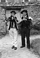
Breton musicians in Brandérion in 1939


literature
- Le Patrimoine des Communes du Morbihan. Flohic Editions, Volume 1, Paris 1996, ISBN 2-84234-009-4 , p. 417.
Individual evidence
- ↑ Sights ( Memento of the original from April 10, 2015 in the Internet Archive ) Info: The archive link was inserted automatically and has not yet been checked. Please check the original and archive link according to the instructions and then remove this notice.