
Lanvaudan
|
Lanvaudan Lanvodan |
||
|---|---|---|
|
||
| region | Brittany | |
| Department | Morbihan | |
| Arrondissement | Lorient | |
| Canton | Guidel | |
| Community association | Lorient agglomeration | |
| Coordinates | 47 ° 54 ′ N , 3 ° 16 ′ W | |
| height | 19-158 m | |
| surface | 18.30 km 2 | |
| Residents | 798 (January 1, 2017) | |
| Population density | 44 inhabitants / km 2 | |
| Post Code | 56240 | |
| INSEE code | 56104 | |
| Website | http://lanvaudan.fr/ | |
 The village church of Saint-Mandé in Lanvaudan |
||

Lanvaudan ( Breton : Lanvodan ) is a French municipality with 798 inhabitants (as of January 1 2017) in the department of Morbihan in the region of Brittany . The municipality belongs to the arrondissement of Lorient and the canton of Guidel .
geography
Lanvaudan is inland in the west of the Morbihan department. The village is located about 19 kilometers northeast of the city of Lorient . Neighboring communities are Inguiniel in the north, Bubry and Quistinic in the east, Languidic in the southeast, Inzinzac-Lochrist in the south and Calan and Plouay in the west.
history
There is little evidence of the early history of the community. Remains from prehistoric and Gallo-Roman times prove an early settlement. In the 12th century a community of monks settled in Kermorc'h. It was ruled by the Burgraves of Pontcallec, who in turn were subject to the rule of Kemenet-Héboé. Later, the municipality was administered by various feudal lords. The most important family were the Lords of Guerholein. From the Middle Ages to the French Revolution, it was an independent parish. Historically, the community belongs to the Pays de Vannes (Vannetais; Breton: Bro-Gwened). After the French Revolution , it was a combat zone between Republican troops and the Chouans. Politically, Lanvaudan became a municipality in 1790. From 1793 on Lanvaudan belonged to the canton of Plouay and the district of Hennebont. From 1801 it was part of the arrondissement of Vannes and until 2015 a municipality in the canton of Plouay. Lanvaudan has been part of the newly created Canton Guidel since March 22, 2015.
Population development
Lanvaudan was one of the smaller communities in the region in 1793 with 965 inhabitants. This remained so despite a slight increase throughout the 19th century. In the period between 1793 and 1906 there were always around 1,000 residents; in the years 1911 to 1946 the population was always around 1,100. In 1926, the historical high population was reached. After the Second World War a strong wave of emigration followed until 1975 (1946-1975: -37%). This was followed by a short phase of growth until 1990 with a subsequent second wave of emigration. In 2006 the all-time low was reached. Since then the population has increased slightly again. The development:
| year | 1793 | 1906 | 1911 | 1926 | 1946 | 1962 | 1968 | 1975 | 1982 | 1990 | 1999 | 2006 | 2012 |
| Residents | 965 | 1.014 | 1,068 | 1,124 | 1,111 | 873 | 785 | 705 | 735 | 815 | 725 | 702 | 753 |
Attractions
See also: List of Monuments historiques in Lanvaudan
- Saint-Mandé village church from 1642
- Saint-Mélec chapel from 1645 in Lomelec
- Old house with a fountain and a decorated dog entrance (lion sculpture)
- Cross on the church square from the 18th century
- Saint-Roch spring fountain
- Former rectory from 1682, next to it an old bread oven and a village well
- Thatched houses from the 16th to 18th centuries Century in Lanvaudan and Kervénic
- Lec'h (a stele) from Gallic times in the church square

The Calvary in the village cemetery
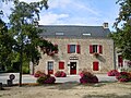
The Lanvaudan Municipal Council ( Mairie )

The thatched house Maison Cardiet

Landscape near Lanvaudan

The Saint-Roch village fountain


literature
- Le Patrimoine des Communes du Morbihan. Flohic Editions, Volume 2, Paris 1996, ISBN 2-84234-009-4 , pp. 680-683.
Individual evidence
- ↑ Sights ( Memento of the original from October 22, 2014 in the Internet Archive ) Info: The archive link was inserted automatically and has not yet been checked. Please check the original and archive link according to the instructions and then remove this notice.