Hennebont
|
Hennebont Henbont |
||
|---|---|---|

|
|
|
| region | Brittany | |
| Department | Morbihan | |
| Arrondissement | Lorient | |
| Canton | Hennebont (main town) | |
| Community association | Lorient agglomeration | |
| Coordinates | 47 ° 48 ′ N , 3 ° 17 ′ W | |
| height | 0-82 m | |
| surface | 18.57 km 2 | |
| Residents | 15,678 (January 1, 2017) | |
| Population density | 844 inhabitants / km 2 | |
| Post Code | 56700 | |
| INSEE code | 56083 | |
| Website | http://www.ville-hennebont.fr/ | |
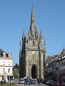
 View of Hennebont |
||
Hennebont ( Breton .: Henbont ) is a commune with 15,678 inhabitants (as of January 1 2017) in the department of Morbihan in the region of Brittany . It belongs administratively to the Arrondissement of Lorient , is the main town ( chef-lieu ) of the canton of Hennebont and is a member of the Lorient Agglomération community association .
geography
The municipality is located on the Blavet about 42 kilometers west-northwest of Vannes and about 9 kilometers northeast of Lorient . Neighboring municipalities are Inzinzac-Lochrist in the northwest and north, Languidic in the northeast, Brandérion in the east, Kervignac in the southeast and south, Lanester in the southwest and Caudan in the west.
history
Hennebont (also Hanebont in early writings ) can be traced back to the Iron Age as a Gallic oppidum. The name of the place indicated an early river crossing over the Blavet. In 1342 the Battle of Hennebont took place here in the War of Succession in Brittany . Johanna von Flanders had fled to Hennebont. From Hennebont she defended her interests and even managed to emerge victorious in the War of Succession.
During the Second World War, Hennebont had to endure an Allied bombardment after the community had already been partially evacuated in 1943.
In February 2016, Hennebont was one of 13 municipalities that belonged to level 3 of the Charter Ya d'ar brezhoneg for the promotion of the Breton language.
Population development
| year | 1962 | 1968 | 1975 | 1982 | 1990 | 1999 | 2006 | 2011 |
| Residents | 11,690 | 11,799 | 12,273 | 12,963 | 13,624 | 13,412 | 14,174 | 15,456 |
Transport links
The municipal area is crossed by the national road N165 ( E60 ). The train station of Hennebont is on de track from Quimper to Nantes ( railway Savenay-Landerneau ). There was a connection to the Chemins de fer du Morbihan network until 1939 and the Lorient tram from 1902–1932 .
Attractions
See also: List of Monuments historiques in Hennebont
- Notre-Dame-de-Joye abbey
- Botanical Garden
- Haras national
- Notre-Dame-de-Paradis Church (built 1514–1530)
- Megalithic tombs
- Towers of Bro-Erec'h
Community partnerships
- Kronach , Bavaria, Germany, since 1990
- Mourdiah , Mali, since 1990
- Mumbles , Wales, United Kingdom, since 2004
- Halhul , Palestine, since 2010
Personalities
- John of Brittany (1295-1345), was Count of Montfort-l'Amaury, as John IV a Duke of Brittany, and Earl of Richmond
- Pierre de Polignac (1895–1964), Prince of Monaco
- Bruno Cremer (1929-2010), actor
- Yves Le Saux (* 1960), Bishop of Le Mans since 2008
- Anthony Le Tallec (born 1984), football player
- Fabien Robert (* 1989), soccer player
- Warren Barguil (* 1991), racing cyclist
literature
- Le Patrimoine des Communes du Morbihan. Flohic Editions, Volume 1, Paris 1996, ISBN 2-84234-009-4 , pp. 418-425.


