Guidel
|
Guidel Gwidel |
||
|---|---|---|

|
|
|
| region | Brittany | |
| Department | Morbihan | |
| Arrondissement | Lorient | |
| Canton | Guidel (main town) | |
| Community association | Lorient agglomeration | |
| Coordinates | 47 ° 47 ′ N , 3 ° 29 ′ W | |
| height | 0-70 m | |
| surface | 52.29 km 2 | |
| Residents | 11,550 (January 1, 2017) | |
| Population density | 221 inhabitants / km 2 | |
| Post Code | 56520 | |
| INSEE code | 56078 | |
| Website | http://www.guidel56.com/ | |
 Guidel |
||
Guidel ( bret. : Gwidel ) is a French municipality with 11,550 inhabitants (as of January 1 2017) in the department of Morbihan in the region of Brittany . The municipality belongs to the arrondissement of Lorient and the canton of Guidel .
geography
Guidel lies on the Atlantic coast and is bounded in the west by the Laïta river , which also forms the border with the Finistere department . The municipality is bounded in the northeast by the Scaff river .
Guidel is surrounded by the neighboring municipalities of Clohars-Carnoët in the west and northwest, Quimperlé in the north, Gestel in the northeast, Quéven in the east and Plœmeur in the southeast.
Attractions
- Dolmens and menhirs as well as tumuli
- Kergal, Kerhar and Locmaria archaeological sites
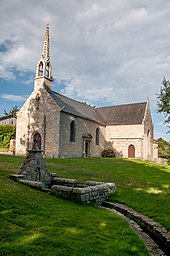
- Saint-Mathieu de Guidel chapel, Gothic building from the 15th century, monument historique since 1934
- Fort du Loch, fortification from 1756, historic monument since 1960
- Manoir de Kerizouët from the 15th century
- 15th century Château de Kerbastic
See also: List of Monuments historiques in Guidel
Community partnerships
Guidel maintains parish partnerships with the following parishes:
- Pulheim , North Rhine-Westphalia, since 1969
- Carrigaline , County Cork, Ireland, since 1987
- Negrești-Oaș , Satu Maru County, Romania, since 1996
Personalities
- Jacques Pâris de Bollardière (1907–1986), Brigadier General
- Jean-Yves Le Drian (* 1947), politician, Minister of Defense (since 2012)
literature
- Le Patrimoine des Communes du Morbihan. Flohic Editions, Volume 2, Paris 1996, ISBN 2-84234-009-4 , pp. 766-768.


