
Quimperlé
|
Quimperlé Kemperle |
||
|---|---|---|
.svg)
|
|
|
| region | Brittany | |
| Department | Finistère | |
| Arrondissement | Quimper | |
| Canton | Quimperlé ( Chef-lieu ) | |
| Community association | Quimperlé Community | |
| Coordinates | 47 ° 52 ′ N , 3 ° 33 ′ W | |
| height | 2-83 m | |
| surface | 31.73 km 2 | |
| Residents | 12,057 (January 1, 2017) | |
| Population density | 380 inhabitants / km 2 | |
| Post Code | 29300 | |
| INSEE code | 29233 | |
| Website | http://www.quimperle.com/ | |

Quimperlé (Bret. Kemperle ) is a town with 12,057 inhabitants (as of January 1, 2017) in north-western France . Quimperle is located in the region of Brittany , Finistere region in Cornwall . The Breton name Kemperle is derived from Kemper Ele (dt. Confluence of the Ele), because here the Isole (Bret. Izol ) flows into the Ellé (Bret. Ele ), which from here forms the estuary called Laïta and finally into the Atlantic flows out.
In February 2016, Quimperlé was one of 13 municipalities that belonged to level 3 of the Charter Ya d'ar brezhoneg for the promotion of the Breton language.


geography
- Altitude level: between 3 m and 83 m at an average of 30 m
- other municipalities in the canton of Quimperlé: Baye, Clohars-Carnoët, Mellac, Tréméven
- Nearby cities: Brest , Concarneau , Le Faou , Le Folgoët , Guimiliau , Landerneau , Morlaix , Penmarc'h , Pleyben , Pont-Aven , Quimper , Saint-Pol-de-Léon , Saint-Thégonnec
The place is on the Route nationale 165 and has a train station on the Savenay – Landerneau railway line .
Population development
| year | 1962 | 1968 | 1975 | 1982 | 1990 | 1999 | 2006 | 2017 |
| Residents | 10,272 | 10,698 | 10,907 | 11,067 | 10,748 | 10,850 | 10,725 | 12,057 |
| Sources: Cassini and INSEE | ||||||||
Town twinning
Sights and museums
See also: List of Monuments historiques in Quimperlé
- Roscasquen dolmen
- Sainte-Croix church, built in the 11th century
- Notre-Dame-de-l'Assomption church (13th century)
- Old town
- city Museum

Sainte-Croix church with covered market
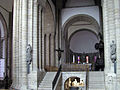
Inside the Sainte-Croix church


Personalities
- Claude-Marie Hervo (1766–1809), General
- Jean-Marc Bideau (* 1984), racing cyclist
literature
- Le Patrimoine des Communes du Finistère. Flohic Editions, Volume 2, Paris 1998, ISBN 2-84234-039-6 , pp. 1344-1362.