
Tréogat
| Tréogat | ||
|---|---|---|
.svg)
|
|
|
| region | Brittany | |
| Department | Finistère | |
| Arrondissement | Quimper | |
| Canton | Plonéour Lanvern | |
| Community association | Haut Pays Bigouden | |
| Coordinates | 47 ° 55 ′ N , 4 ° 19 ′ W | |
| height | 0-51 m | |
| surface | 9.85 km 2 | |
| Residents | 581 (January 1, 2017) | |
| Population density | 59 inhabitants / km 2 | |
| Post Code | 29720 | |
| INSEE code | 29298 | |
 Mairie Tréogat |
||

Tréogat ( Breton Trêgad ) is a French commune with 581 inhabitants (as of January 1, 2017) in the Finistère department . The inhabitants are called Tréogatais .
The name Tréogat may have been derived from the Breton word for locality ( treb ) and the patron saint of the local church Saint-Boscat ( Bozgat ), which in turn is composed of the terms Beuz (for victory) and Kad (for battle).
geography
The place is located in the southwest of Brittany , a good four kilometers from the Atlantic coast inland. Plonéour-Lanvern , the largest city in the canton, is also about four kilometers south-east and the Préfecture of the department, Quimper , is about 18 kilometers north-east of Tréogat.
Via Quimper there are connections to Europastraße 60 (E 60) and thus the international trunk road network. In Quimper there is also the next larger train station , which is integrated into the TGV Atlantique network.
history
The place was first mentioned in the 14th century, and Tréogat first appeared under the name known today at the end of the 16th century. The community used to belong to the medieval kingdom and diocese of Cornouaille with the capital Quimper.
Population development
Tréogat had its highest population at the beginning of the 20th century, when almost 800 inhabitants were counted.
| year | 1962 | 1968 | 1975 | 1982 | 1990 | 1999 | 2008 | 2017 |
| Residents | 594 | 519 | 416 | 419 | 420 | 398 | 519 | 581 |
| Sources: Cassini and INSEE | ||||||||
Attractions
The Saint-Boscat church dates from the late 14th and first half of the 15th centuries. In addition to prehistoric megaliths, there are numerous remains of medieval religious symbols, such as the Cross of Kerguenol from 1500 as well as the Manoir de Minven from the 16th century and the Lavoir de Ty-Poul.
In the territory of the municipality of Tréogar, part of the "Route du Vent Solaire" (road of the solar wind) runs, more precisely behind the dunes on the long-distance hiking trail GR 34. This wilderness area is largely managed by the coastal protection Conservatoire du Littoral. There are ponds and swamps alternating with each other.
Pond Etang de Trunvel
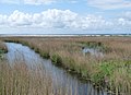
The Trunvel pond is the most famous part of the Bay of Audierne and belongs to the municipality of Tréogat. It is even of international importance in terms of the reed warbler bird migration, which is attracted by the wide reed areas. The bird ringing station at the pond is open to visitors every morning.
Pond Etang de Kergalan
He also belongs to the municipality of Tréogat. Rare bird species are also drawn here, especially in autumn near the sea (pebble hill chain and beach).
Pebble necklace ( Ero Vili )
A ten kilometer long chain of dunes adorns the Bay of Audierne between Penhors and the headland of Pointe de la Torche. Part of the area lies in the coastal area of the municipality of Tréogat. Originally this coastal strip consisted of a pebble chain, rolled gravel and sand. The height fluctuated between the +8.00 mark and sometimes +7.00 compared to the zero mark on the nautical charts of Penmarc'h. The pebble chain used to be 50 m wide. The vulnerability of this area had been recognized long before World War II . From March 1934 onwards, nothing could be dismantled on this stretch of coast by an order from the prefecture. Heavy storms break through this narrow strip of pebbles and wash parts of the beaches.
Moulin de Bondivy
The historic Moulin de Bondivy is located on the border of the municipalities of Tréogat and Plonéour-Lanvern near the road D 2. The mill was built around 1828 as a square, one-storey structure with broken stones and a slate roof with long sloping ceilings. The still intact mechanism of the mill dates from the end of the 19th century. Just like the three hectare pond in the immediate vicinity, the mill is privately owned.
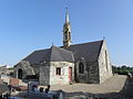
Saint Boscat Church in Tréogat

Calvary at the Saint Boscat church in Tréogat

Monument aux morts in Tréogat
View of part of the Bay of Audierne near Tréogat
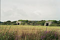
so-called log houses from Kreyéré near Tréogat of the German Wehrmacht

English HSM Mauritius fired from the sea into the Bay of Audierne on 23 August 1944

Étangs de Trunvel and Kergalon at Tréogat

Pebble chain (Ero Vili) in the Bay of Audierne
_%C3%89glise_Saint-Boscat_03.JPG)
_%C3%89glise_Saint-Boscat_06.JPG)
_Monument_aux_morts.JPG)


literature
- Le Patrimoine des Communes du Finistère. Flohic Editions, Volume 2, Paris 1998, ISBN 2-84234-039-6 , pp. 952-953.
Individual evidence
- ↑ www.geobreizh.com ( page no longer available , search in web archives ) Info: The link was automatically marked as defective. Please check the link according to the instructions and then remove this notice.
- ↑ Infobretagne.com
- ↑ cassini.ehess.fr
- ^ French Ministry of Culture