Locmiquélic
|
Locmiquélic Lokmikaelig |
||
|---|---|---|

|
|
|
| region | Brittany | |
| Department | Morbihan | |
| Arrondissement | Lorient | |
| Canton | Hennebont | |
| Community association | Lorient agglomeration | |
| Coordinates | 47 ° 44 ′ N , 3 ° 20 ′ W | |
| height | 0-24 m | |
| surface | 3.58 km 2 | |
| Residents | 4,046 (January 1, 2017) | |
| Population density | 1,130 inhabitants / km 2 | |
| Post Code | 56570 | |
| INSEE code | 56118 | |
| Website | http://www.ville-locmiquelic.fr/ | |
Locmiquélic ( Breton .: Lokmikaelig ) is a French municipality with 4046 inhabitants (as of January 1 2017) in the department of Morbihan in the region of Brittany . Locmiquelic belongs to the Arrondissement of Lorient and the Canton of Port-Louis . The inhabitants are called Locmiquélicain (e) s .
geography
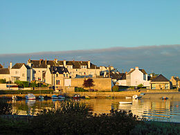
Locmiquélic lies at the mouth of the Blavet (the so-called roadstead of Lorient) to the Atlantic . Locmiquélic is surrounded by the neighboring communities of Lanester in the north on the opposite side of the Blavet, Kervignac in the northeast, Merlevenez in the east, Riantec in the east and south, Port-Louis in the southwest and Lorient in the northwest on the opposite side of the Blavet estuary.
Two marinas offer anchorage for yachts and sailboats: Sainte-Catherine and Pen Mané.
history
Formerly part of the municipality of Riantec, Locmiquélic has been an independent municipality since 1919.
Population development
| 1962 | 1968 | 1975 | 1982 | 1990 | 1999 | 2006 | 2011 |
|---|---|---|---|---|---|---|---|
| 4,456 | 4,542 | 4,284 | 4,002 | 4,094 | 3,945 | 4.125 | 4,186 |
Attractions
- Saint-Michel church
- Old chapel
Personalities
- Jacques Chazot (1928–1993), dancer
literature
- Le Patrimoine des Communes du Morbihan. Flohic Editions, Volume 2, Paris 1996, ISBN 2-84234-009-4 , pp. 780-781.

