Locoal-Mendon
|
Locoal-Mendon Lokoal-Mendon |
||
|---|---|---|
|
|
||
| region | Brittany | |
| Department | Morbihan | |
| Arrondissement | Lorient | |
| Canton | Quiberon | |
| Community association | Auray Quiberon Terre Atlantique | |
| Coordinates | 47 ° 43 ′ N , 3 ° 6 ′ W | |
| height | 0-42 m | |
| surface | 39.97 km 2 | |
| Residents | 3,416 (January 1, 2017) | |
| Population density | 85 inhabitants / km 2 | |
| Post Code | 56550 | |
| INSEE code | 56119 | |
| Website | www.locoal-mendon.fr | |
 Location of the municipality on the Ria d'Étel |
||
Locoal-Mendon is a French municipality with 3416 inhabitants (at January 1, 2017) in the department of Morbihan in the region of Brittany .
geography
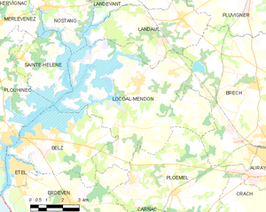
The municipality is located in the southwest of the department between the agglomerations of Lorient and Vannes , about five kilometers northwest of the city of Auray .
Locoal-Mendon borders the municipality of Landaul in the north, Brech in the east, Ploemel and Erdeven in the south, Belz in the south-west and the Étel , a coastal river in the west , which becomes a branched sea bay in the estuary ( Ria d'Étel ) expands. The western parts of the municipality extend into this bay as peninsulas.
history
There are several dolmens from prehistoric times in the municipality ( Dolmen Mané-er-Loh and Dolmen de Locqueltas ).
The district of Locoal goes back to a hermitage of Saint Goal, an English monk who came to this area around 631 AD for Christian missionary work. Mendon was created in the 10th century by dividing the area of Ploemel . The annexation of Locoal to Mendon under the name Locoal-Mendon took place in 1806 by Napoleonic resolution.
Attractions
See also: List of Monuments historiques in Locoal-Mendon
- Locoal Peninsula
- Saint-Goal Church (Locoal)
- Saint-Pierre Church (Mendon)
Economy and Infrastructure
While the center and the east around the settlement areas Mendon and Lapaul are dominated by agriculture, the western parts of the municipality are influenced by the water situation and the tidal currents of the Ria d'Étel . As everywhere on the Ria, oyster farms are also located here .
In the northeast of the municipality there is a small industrial area north of the N165.
traffic
The municipality is stripped to the northeast by the N165 expressway ( Brest - Quimper - Lorient - Vannes - Nantes ). The approach to the N165 is in the northern neighboring municipality of Landaul on the D16, which connects the district of Mendon with Landaul and Pluvigner in the northeast and Belz and Étel in the southwest.
Outside of school traffic , the municipal area is only served by local public transport on Auray market day . Approx. one kilometer north of the municipal boundary is the station Landaul-Mendon , where several times a day regional train TER Bretagne (route Lorient - Vannes ) hold (as of December 2013). The nearest long-distance train station is in Auray and the nearest airport is Lorient Bretagne Sud .
literature
- Le Patrimoine des Communes du Morbihan. Flohic Editions, Volume 1, Paris 1996, ISBN 2-84234-009-4 , pp. 160-163.
Web links
- Locoal-Mendon commune (French)
Individual evidence
- ↑ http://www.infobretagne.com/locoal-mendon.htm accessed on December 26, 2013 (French)
- ↑ http://locoaletmendon.online.fr/eglise_mendon.htm accessed on December 26, 2013 (French)


