
Locmariaquer
|
Locmariaquer Lokmaria-Kaer |
||
|---|---|---|

|
|
|
| region | Brittany | |
| Department | Morbihan | |
| Arrondissement | Lorient | |
| Canton | Auray | |
| Community association | Auray Quiberon Terre Atlantique | |
| Coordinates | 47 ° 34 ′ N , 2 ° 57 ′ W | |
| height | 0-19 m | |
| surface | 10.99 km 2 | |
| Residents | 1,566 (January 1, 2017) | |
| Population density | 142 inhabitants / km 2 | |
| Post Code | 56740 | |
| INSEE code | 56116 | |
| Website | www.locmariaquer.fr | |
 Locmariaquer |
||

Locmariaquer ( Breton: Lokmaria-Kaer ) is a French municipality with 1566 inhabitants (at January 1, 2017) in the department of Morbihan in the region of Brittany , which has become internationally known mainly because of the many impressive monuments from the megalithic.
location
Locmariaquer is about ten kilometers (driving distance) south of Auray on a peninsula that separates the Atlantic from the Gulf of Morbihan . The place is at sea level and about twelve kilometers from Carnac .
Population development
| year | 1968 | 1975 | 1982 | 1990 | 1999 | 2006 |
| Residents | 1,265 | 1,288 | 1,278 | 1,309 | 1,367 | 1,598 |
The place had around 2,000 inhabitants for almost the entire 19th century.
economy
Oyster farming
Oyster farming has been practiced in the Gulf of Morbihan since the end of the 19th century , with the cultivation of young mussels now only playing an important economic role. There are still around 30 small businesses that switched to Japanese and Pacific oysters after the oyster crisis in 1973/4, which was caused by parasites. In the years after 2006, however, there was another oyster crisis in France. Locmariaquer used to have a small fishing port; meanwhile the place and its surroundings are considered good places for anglers. The hinterland is used for agriculture.
tourism
The climatically stable south of Brittany with its many bays and sandy beaches already attracted many French holidaymakers before the Second World War. Since the 1960s, the importance of tourism for economic life has increased more and more. There are also many sandy beaches and marinas as well as smaller guest houses and larger hotels in the vicinity of Locmariaquer ( Saint-Philibert , La Trinité-sur-Mer , Carnac, Quiberon peninsula ).
history
As can be deduced from the many important large stone buildings ( dolmen of Kercadoret , Les Pierres-Plates , Mané-er-Hroëk , dolmen on the Pointe Er Hourél ), the area of the Gulf of Morbihan must have played an important role in the time of the megalithic cultures It is important to note that many older grand menhirs were built around 4200 BC. BC - probably on purpose - were overturned; the resulting sections were reused as cover plates (sometimes also as orthostats) in the dolmen located in the village ( Er Grah , Mané Lud , Mané Retual , Table des Marchand ). In front of the access to the Table des Marchand and in the dolmen of Kercadoret - as one of the few artefacts from the Bronze Age - a bronze ax or spear and arrowheads made of bronze were found; it is possible that the dolmens were used during this period (perhaps even earlier).
The sparse remains of a theater , an aqueduct and a thermal baths within today's community date from Roman times , which were discovered during excavations at the end of the 19th century, but then mostly buried again. The Chapelle Saint-Michel was built on the foundation walls of a small Roman temple; from the 11th / 12th Notre-Dame-de-Kerdro church dates back to the 16th century . In the Middle Ages and modern times, the place was always settled, but no longer played an important economic, political or cultural role.
Attractions
- Megalithic time

The place with its many sights from the epoch of the megalithic cultures is a destination for many tourists today; the most important monuments of this time are:
- Table des Marchand ( Dolmen and Cairn )
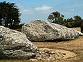
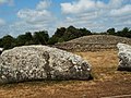
- Grand Menhir -Brisé (broken menhir )
- Er Grah (Dolmen and Tumulus )

- Mané Lud (dolmen and tumulus)
- Mané Rutual (passage grave)
- Les Pierres-Plates (passage grave)
- Mané-er-Hroek (grotto and tumulus)
The menhir couché by Bronso is a broken menhir in the north-west of Locmariaquer
- middle Ages

- Catholic parish church of Notre-Dame-de-Kerdro with Romanesque crossing and apse and Romanesque capitals ( Monument historique )
- A little outside the town center there are two idyllic chapels ( Chapelle Saint-Pierre and the Chapelle du Moustoir )
See also: List of the Monuments historiques in Locmariaquer
Surroundings
The small but impressive dolmen of Kercadoret is only four kilometers northwest of Locmariaquer. In the outskirts of the town of Carnac , only twelve kilometers away, are the famous megalithic stone rows ( alignments ) of Le Menec , Kerlescan and Kermario . In the center of Carnac there is a worth seeing museum on megalithic culture ( Musée de Préhistoire ). From the small town of Larmor-Baden on the eastern bank of the Gulf of Morbihan, boats go to the island of Gavrinis .

Grand Menhir - general view

Grand Menhir - general view
Grand Menhir - partial view of the fracture point
Grand menhir and reconstructed hill of the 'Table des Marchand'


Table des Marchand - entrance with a reconstructed Trilith portal
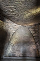
Table des Marchand - interior view including partial reconstruction
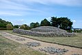
Restored cairn of the Table des Marchand and floor markings of a menhir avenue.
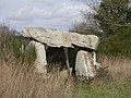
Dolmen of Kercadoret front

.jpg)


literature
- Le Patrimoine des Communes du Morbihan. Flohic Editions, Volume 1, Paris 1996, ISBN 2-84234-009-4 , pp. 80-83.
Individual evidence
- ↑ Église Notre-Dame-de-Kerdro in the Base Mérimée of the French Ministry of Culture (French)
Web links
- Locmariaquer commune (French)
- Megalithic monuments in Locmariaquer (French)
- Locmariaquer - Ville Romaine (French)
- Locmariaquer - history, photos + text (French)
- Dolmen of Kercadoret (English)