
Plouhinec (Morbihan)
|
Plouhinec Pleheneg |
||
|---|---|---|
.svg)
|
|
|
| region | Brittany | |
| Department | Morbihan | |
| Arrondissement | Lorient | |
| Canton | Pluvigner | |
| Community association | Blavet Bellevue Océan | |
| Coordinates | 47 ° 42 ′ N , 3 ° 15 ′ W | |
| height | 0-25 m | |
| surface | 35.58 km 2 | |
| Residents | 5,353 (January 1, 2017) | |
| Population density | 150 inhabitants / km 2 | |
| Post Code | 56680 | |
| INSEE code | 56169 | |
| Website | http://www.plouhinec.com/ | |
 Church of Our Lady of Grace in Plouhinec |
||

Plouhinec ( Breton .: Pleheneg ) is a commune with 5353 inhabitants (at January 1, 2017) in the Morbihan department in the region of Brittany .
geography
The municipality is located in the southwest of the department about ten kilometers southeast of the agglomeration of Lorient . Plouhinec borders in the north-west and north on the municipality of Merlevenez , in the northeast on the municipality of Sainte-Hélène , in the east on the Ria d'Étel , in the south on the Atlantic coast and in the west on the municipality of Gâvres , the Bay of Petite mer de Gâvres and the Riantec municipality .
The main areas of settlement are to the west with the town of Plouhinec and to the east on the Ria d'Étel, over which the Pont Lorois suspension bridge leads to the municipality of Belz .
history
Menhirs , dolmens and rows of stones (e.g. the Alignements du Gueldro ) can be found in the municipality from prehistoric times . Above the bank of the Étel, near Locquénin , there are excavations of a Gallo-Roman property from the 2nd century AD ( Ville maritime de Mané-Vechen ). The Breton settlement takes place from the 6th century. The name Plouhinec goes back to the Breton "Ploe-Hidinuc" from the 11th century. The Plouhinec commune was founded in 1790.
Attractions
See also: List of Monuments historiques in Plouhinec (Morbihan)
- Romanesque church of Saint-Guénin from the 11th century in Locquénin
- Neo-Gothic church Notre-Dame de Grâce in 1872 in Plouhinec
- Suspension bridge Pont Lorois with a view of the Ria d'Étel
- Mané-Véchen excavation site (remains of a Gallo-Roman villa)
- Alignements by Kerzine , also called Alignements du Gueldro
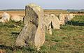
Alignements du Gueldro

Mané-Véchen excavation site

map

Pont Lorois with a view of the Le Passage Neuf district


traffic
The municipality is connected to the north via the department road D 9 to Hennebont on the French trunk road network ( N 24 , N 165 ) and the greater Lorient area west of the Blavet . The D 9 leads in the east over the Pont Lorois to Belz and further as the D 22 to Auray . The D 781 connects the coastal towns from Port-Louis in the west to Locmariaquer in the south-east. The place had a train station of the Chemins de fer du Morbihan , of which the Rue de la Gare still reminds us.
The next regional train station is in Hennebont, with long-distance connections in Auray. The closest airport is Lorient Bretagne Sud . There are bus connections (Monday to Saturday) to Lorient, Port Louis, Belz-Auray and La Trinité-sur-Mer .
Partner communities
Community partnerships exist with:
- Kilkee , Ireland , since 1982
- Weidenberg , Germany , since 1989
literature
- Le Patrimoine des Communes du Morbihan. Flohic Editions, Volume 2, Paris 1996, ISBN 2-84234-009-4 , pp. 784-785.
Web links
- Official website of the municipality (French)
Individual evidence
- ↑ Archived copy ( Memento of the original from December 28, 2013 in the Internet Archive ) Info: The archive link was inserted automatically and has not yet been checked. Please check the original and archive link according to the instructions and then remove this notice. Retrieved December 27, 2013
- ↑ Réseau des Transports Interurbains du Morbihan (TIM) ( Memento of the original from December 15, 2013 in the Internet Archive ) Info: The archive link has been inserted automatically and has not yet been checked. Please check the original and archive link according to the instructions and then remove this notice. Status: December 2013