
Fouras
| Fouras | ||
|---|---|---|

|
|
|
| region | Nouvelle-Aquitaine | |
| Department | Charente-Maritime | |
| Arrondissement | Rochefort | |
| Canton | Châtelaillon plague | |
| Community association | Rochefort Ocean | |
| Coordinates | 45 ° 59 ′ N , 1 ° 6 ′ W | |
| height | 0-21 m | |
| surface | 9.51 km 2 | |
| Residents | 4,006 (January 1, 2017) | |
| Population density | 421 inhabitants / km 2 | |
| Post Code | 17450 | |
| INSEE code | 17168 | |
| Website | www.fouras.net | |
 Fouras Town Hall |
||

Fouras (also: Fouras-les-Bains ) is a French municipality with 4006 inhabitants (as of January 1 2017) in the department of Charente-Maritime in the region Nouvelle-Aquitaine . Fouras belongs to the arrondissement of Rochefort and the canton of Châtelaillon-Plage . The inhabitants are called Fourasin (e) s .
geography

Fouras lies with its five beaches on the Atlantic Ocean on a peninsula. Here the Charente river flows into the Atlantic. From Fouras ferries go to the offshore islands, i. H. to Fort Énet and the island of Aix . Fouras is surrounded by the neighboring communities of Yves in the north, Saint-Laurent-de-la-Prée in the east and Port-des-Barques in the south.
history
As a strategically important place, Fouras has always been the subject of disputes. In order to protect themselves from the Vikings, the construction of fortifications began early on. During the wars of religion, Fouras was occupied by the Protestants. In 1809 there was a major sea battle off Fouras for the island of Aix. During the Second World War, Fouras was held by the Germans for a very long time.
Population development
| year | 1962 | 1968 | 1975 | 1982 | 1990 | 1999 | 2006 | 2016 |
|---|---|---|---|---|---|---|---|---|
| Residents | 4121 | 3634 | 3612 | 3295 | 3238 | 3835 | 4024 | 4046 |
Attractions
See also: List of Monuments historiques in Fouras
- Saint-Gaudens church, built in 1883 in the neo-Gothic style to replace the previous 11th century church
- Fort de Fouras (also: Fort Vauban ), built by Philip IV at the beginning of the 14th century , rebuilt in 1672, used as a semaphore station, Monument historique since 1987
.JPG)
- Fort Énet , upstream island bulwark, built in the Napoleonic Wars (1809–1811), since 1994 Monument historique
- Fortifications of Aiguille ( Redoutenanlage )
- Fort Lapointe (also called Fort Vasou ), built in 1672 on the Charente estuary
- Town hall, built in 1902
- Bois-Vert Castle, built in 1870 as a neoclassical building

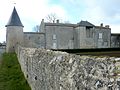
- Treuil-Bussac Castle from the 17th century
- Villa La Jetée (also Château Bugeau ), built in 1903, monument historique since 2007
- numerous beach villas
- Aubier, Espérance and Soumard mills, mostly converted into residential buildings
Treuil-Bussac Castle

Villa La Jetée

Espérance mill

Saint-Gaudens church

The great beach of Fouras


Community partnerships
There is a partnership with the French commune of Riom-ès-Montagnes in the Cantal department, together with the commune of Île-d'Aix.
Personalities
- Charles Amable Lenoir (1860–1926), painter
literature
- Le Patrimoine des Communes de la Charente-Maritime. Flohic Editions, Volume 2, Paris 2002, ISBN 2-84234-129-5 , pp. 619-622.