Seudre
| Seudre | ||
|
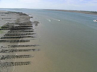
The mouth of the Seudre |
||
| Data | ||
| Water code | FR : S01-0400 | |
| location | France , Nouvelle-Aquitaine region | |
| River system | Seudre | |
| source | in Saint-Antoine , municipality of Saint-Genis-de-Saintonge 45 ° 27 ′ 43 " N , 0 ° 35 ′ 59" W |
|
| Source height | approx. 40 m | |
| muzzle | near Marennes , in the Atlantic Coordinates: 45 ° 48 ′ 30 ″ N , 1 ° 9 ′ 0 ″ W 45 ° 48 ′ 30 ″ N , 1 ° 9 ′ 0 ″ W. |
|
| Mouth height | 0 m | |
| Height difference | approx. 40 m | |
| Bottom slope | approx. 0.59 ‰ | |
| length | 68 km | |
| Catchment area | 777 km² | |
| Small towns | Saujon , Marennes | |
| Navigable | from the estuary to Port de Ribérou , municipality of Saujon | |
The Seudre is a coastal river in France that runs in the Charente-Maritime department , in the Nouvelle-Aquitaine region . It rises in the Saintonge countryside , in the village of Saint-Antoine , in the municipality of Saint-Genis-de-Saintonge . The initially rather insignificant river generally drains in a north-westerly direction and flows into the Atlantic after 68 kilometers between Marennes and Ronce-les-Bains , in the municipality of La Tremblade , in an imposing confluence opposite the island of Île d'Oléron .
The estuary of the Seudre runs through wetlands , swamps and former salt fields . Today, oysters and mussels are mainly raised here, and these are marketed under the Marennes-Oléron Designation of Origin .
shipping
The Seudre is navigable by ship over a length of 25 kilometers from its mouth to Port de Ribérou , in the municipality of Saujon . There is a sea water is sluice that the brackish water conditions upstream limited.
The ship channel Canal de la Seudre à la Charente connects the Seudre with the river Charente between the cities of Marennes and Rochefort .
Places on the river
- Saint-Germain-du-Seudre
- Saint-André-de-Lidon
- Corme-Écluse
- Saujon
- Étaules
- La Tremblade
- Marennes
- Ronce-les-Bains
Web links
Remarks
- ↑ a b geoportail.fr (1: 16,000)
- ↑ a b c The information on the length of the river is based on the information on the relevant website sandre.eaufrance.fr/ accessed on August 10, 2009, rounded to full kilometers.
