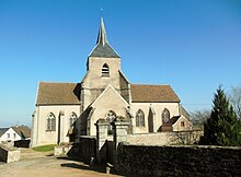
Saint-Léger-Vauban
| Saint-Léger-Vauban | ||
|---|---|---|

|
|
|
| region | Bourgogne-Franche-Comté | |
| Department | Yonne | |
| Arrondissement | Avallon | |
| Canton | Avallon | |
| Community association | Avallon, Vezelay, Morvan | |
| Coordinates | 47 ° 23 ' N , 4 ° 2' E | |
| height | 325-566 m | |
| surface | 33.81 km 2 | |
| Residents | 360 (January 1, 2017) | |
| Population density | 11 inhabitants / km 2 | |
| Post Code | 89630 | |
| INSEE code | 89349 | |
Saint-Léger-Vauban is a French commune with 360 inhabitants (as of January 1, 2017) in the Arrondissement of Avallon , in the Yonne department and in the Bourgogne-Franche-Comté region .
The municipality is located in the Morvan Regional Nature Park ( French Parc naturel régional du Morvan ). It is the birthplace of the architect Sébastien le Prestre de Vauban , who built fortresses for the French King Louis XIV in the 17th century . In his honor, the original place name Saint-Léger-Foucheret was renamed Saint-Léger-Vauban in 1867. In the forests of the Morvan is Benedictine - Abbey Sainte Marie de la Pierre-qui-Vire , which was only founded in the 1850th
Attractions
- Saint-Léger church
- Vauban's birthplace
- Pierre-qui-Vire Abbey
- Château de Ruères
Web links
Commons : Saint-Léger-Vauban - Collection of images, videos and audio files

