
Cry (Yonne)
| Cry | ||
|---|---|---|
|
||
| region | Bourgogne-Franche-Comté | |
| Department | Yonne | |
| Arrondissement | Auxerre | |
| Canton | Tonnerrois | |
| Community association | Le Tonnerrois en Bourgogne | |
| Coordinates | 47 ° 42 ' N , 4 ° 14' E | |
| height | 184-292 m | |
| surface | 11.16 km 2 | |
| Residents | 170 (January 1, 2017) | |
| Population density | 15 inhabitants / km 2 | |
| Post Code | 89390 | |
| INSEE code | 89132 | |

Cry is a French commune with 170 inhabitants (as of January 1, 2017) in the Yonne department in the Bourgogne-Franche-Comté region (before 2016 Bourgogne ) in eastern France . The municipality belongs to the Arrondissement Avallon and the canton Tonnerrois ( Ancy-le-Franc until 2015 ).
geography
Cry is about 43 kilometers east-southeast of Auxerre on the Armançon . Cry is surrounded by the neighboring communities of Nuits in the north and north-west, Ravières in the north, Asnières-en-Montagne in the east and north-east and Perrigny-sur-Armançon in the south and south-west.
The municipality is located in the Bourgogne wine region .
Population development
| year | 1962 | 1968 | 1975 | 1982 | 1990 | 1999 | 2006 | 2013 |
|---|---|---|---|---|---|---|---|---|
| Residents | 233 | 220 | 232 | 215 | 181 | 170 | 179 | 178 |
| Source: Cassini and INSEE | ||||||||
Attractions
- Saint-Julien church, crypt monument historique since 1965
- 15th century stone bridge

Saint-Cry church
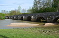
Stone bridge


Web links
Commons : Cry - collection of images, videos and audio files