
Ancy-le-Franc
| Ancy-le-Franc | ||
|---|---|---|

|
|
|
| region | Bourgogne-Franche-Comté | |
| Department | Yonne | |
| Arrondissement | Avallon | |
| Canton | Tonnerrois | |
| Community association | Le Tonnerrois en Bourgogne | |
| Coordinates | 47 ° 47 ' N , 4 ° 10' E | |
| height | 169-302 m | |
| surface | 19.65 km 2 | |
| Residents | 908 (January 1, 2017) | |
| Population density | 46 inhabitants / km 2 | |
| Post Code | 89160 | |
| INSEE code | 89005 | |

Ancy-le-Franc is a French village with 908 inhabitants (as of January 1 2017) in the Yonne department in the region of Bourgogne Franche-Comté ; it belongs to the Arrondissement Avallon and the canton Tonnerrois (until 2015: canton Ancy-le-Franc ).
geography
Ancy-le-Franc is about 44 kilometers east of Auxerre . Ancy-le-Franc is surrounded by the neighboring communities of Ancy-le-Libre in the north and northwest, Gland in the northeast, Chassignelles in the east, Fulvy in the south, Villers-les-Hauts in the south and southwest, Argenteuil-sur-Armançon in the west and Southwest and Pacy-sur-Armançon to the west.
Population development
| year | 1962 | 1968 | 1975 | 1982 | 1990 | 1999 | 2006 | 2013 |
| Residents | 1,056 | 1,059 | 1,236 | 1,188 | 1,174 | 1.108 | 1,089 | 958 |
| Source: Cassini and INSEE | ||||||||
Attractions
- Sainte-Colombe Church
- Ancy-le-Franc castle from the 16th century, monument historique since 1983
- Grave chapel of the Le Cosquinot family from the 16th century, a historic monument since 1925

Sainte-Colombe Church
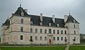
Ancy-le-Franc castle


Web links
Commons : Ancy-le-Franc - collection of images, videos and audio files