
Nuits
| Nuits | ||
|---|---|---|
|
||
| region | Bourgogne-Franche-Comté | |
| Department | Yonne | |
| Arrondissement | Avallon | |
| Canton | Tonnerois | |
| Community association | Le Tonnerrois en Bourgogne | |
| Coordinates | 47 ° 44 ' N , 4 ° 13' E | |
| height | 179-262 m | |
| surface | 11.58 km 2 | |
| Residents | 399 (January 1, 2017) | |
| Population density | 34 inhabitants / km 2 | |
| Post Code | 89390 | |
| INSEE code | 89280 | |
| Website | http://www.mairie-nuits.fr/ | |
 Town Hall (Mairie) of Nuits |
||

Nuits (formerly: Nuits-sous-Ravière ) is a French commune with 399 inhabitants (as of January 1, 2017) in the Yonne department in the Bourgogne-Franche-Comté region (before 2016 Bourgogne ) in eastern France . The municipality belongs to the Arrondissement Avallon and the canton Tonnerrois ( Ancy-le-Franc until 2015 ). The inhabitants are called nuitons .
geography
Nuits is located about 55 kilometers east-southeast of Auxerre on the Armançon , which borders the municipality in the east. Nuits is surrounded by the neighboring communities of Villiers-les-Hauts in the north and west, Chassignelles in the north, Ravières in the east, Cry in the south and south-east, Perrigny-sur-Armançon in the south and south-west and Étivey in the west.
Population development
| year | 1962 | 1968 | 1975 | 1982 | 1990 | 1999 | 2006 | 2013 |
|---|---|---|---|---|---|---|---|---|
| Residents | 619 | 556 | 499 | 453 | 455 | 407 | 417 | 408 |
| Source: Cassini and INSEE | ||||||||
Attractions
- Saint-Cyr-et-Sainte-Julitte church
- Saint-Marc chapel from the 13th century, monument historique since 1967
- Nuits castle from the 16th century, monument historique since 1967
- Columns of Nuits (18th century) and fortified town gate (16th century), each monument historique since 1969

Saint-Cyr-et-Sainte-Julitte church

Nuits Castle
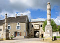
Pillars and gate


Personalities
- Pierre-Anastase Pichenot (1816–1880), Bishop of Tarbes (1870–1873), Archbishop of Chambéry (1873–1880)