Étaule
| Étaule | ||
|---|---|---|
|
|
||
| region | Bourgogne-Franche-Comté | |
| Department | Yonne | |
| Arrondissement | Avallon | |
| Canton | Avallon | |
| Community association | Avallon, Vezelay, Morvan | |
| Coordinates | 47 ° 31 ' N , 3 ° 55' E | |
| height | 190-330 m | |
| surface | 8.89 km 2 | |
| Residents | 369 (January 1, 2017) | |
| Population density | 42 inhabitants / km 2 | |
| Post Code | 89200 | |
| INSEE code | 89159 | |
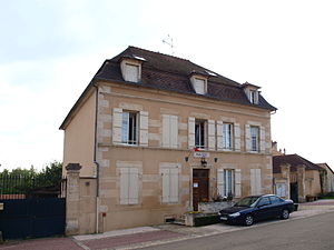
 Town hall (Mairie) of Étaule |
||
Étaule is a French municipality with 369 inhabitants (as of January 1 2017) in the department of Yonne in the region Bourgogne Franche-Comté . It belongs to the Arrondissement of Avallon and the Canton of Avallon .
The municipality consists of the places Étaule-le-Bas and Vassy-lès-Avallon .
geography
Étaule is located about 43 kilometers south-southeast of Auxerre . The municipality is crossed by the Vau de Bouche river, also known as the Ruisseau du Moulin in this section . Étaule is surrounded by the neighboring communities of Lucy-le-Bois in the north and north-west, Thory in the north, Provency in the east and north-east, Sauvigny-le-Bois in the east and south-east, Avallon in the south, Annéot in the west and south-west and Annay-la- Côte to the west and northwest.
Population development
| year | 1962 | 1968 | 1975 | 1982 | 1990 | 1999 | 2006 | 2013 |
| Residents | 298 | 327 | 298 | 335 | 393 | 409 | 418 | 389 |
| Source: Cassini and INSEE | ||||||||
Attractions
- Saint-Valentin church, rebuilt in 1705
- Vassy Church, built between 1859 and 1862
- Castle from 1873
- Fortified house from the 16th century


