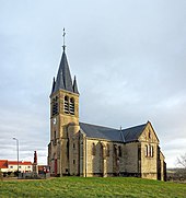
Sennevoy-le-Haut
| Sennevoy-le-Haut | ||
|---|---|---|
|
|
||
| region | Bourgogne-Franche-Comté | |
| Department | Yonne | |
| Arrondissement | Auxerre | |
| Canton | Tonnerrois | |
| Community association | Le Tonnerrois en Bourgogne | |
| Coordinates | 47 ° 48 ' N , 4 ° 17' E | |
| height | 238-320 m | |
| surface | 8.84 km 2 | |
| Residents | 118 (January 1, 2017) | |
| Population density | 13 inhabitants / km 2 | |
| Post Code | 89160 | |
| INSEE code | 89386 | |
Sennevoy-le-Haut is a French commune with 118 inhabitants (as of January 1, 2017) in the Yonne department in the Bourgogne-Franche-Comté region (before 2016 Bourgogne ) in eastern France . The municipality belongs to the Arrondissement Avallon and the canton Tonnerrois (until 2015 Cruzy-le-Châtel ).
geography
Sennevoy-le-Haut is about 56 kilometers east of Auxerre . Sennevoy-le-Haut is surrounded by the neighboring communities of Cruzy-le-Châtel in the north and north-west, Gigny in the east and north-east, Sennevoy-le-Bas in the east, Jully in the south-east, Stigny in the south and Gland in the north-west.
Population development
| year | 1962 | 1968 | 1975 | 1982 | 1990 | 1999 | 2006 | 2013 |
|---|---|---|---|---|---|---|---|---|
| Residents | 198 | 185 | 180 | 172 | 155 | 157 | 155 | 129 |
| Source: Cassini and INSEE | ||||||||
Attractions
- L'Immaculée-Conception church
Personalities
- François d'Arbaud de Porchères (1590–1640), poet and member of the Académie française , died in Sennevoy-le-Haut
- Baron du Potet (1796–1881), esotericist
Web links
Commons : Sennevoy-le-Haut - collection of images, videos and audio files

